IMAGES TAKEN NEAR TO
Sandy Lane, DUKINFIELD, SK16 5NL
Introduction
This page details the photographs taken nearby to Sandy Lane, SK16 5NL by members of the Geograph project.
The Geograph project started in 2005 with the aim of publishing, organising and preserving representative images for every square kilometre of Great Britain, Ireland and the Isle of Man.

There are currently over 7.5m images from over14,400 individuals and you can help contribute to the project by visiting https://www.geograph.org.uk
Image Map
Images are licensed for reuse under creativecommons.org/licenses/by-sa/2.0
Notes
- Clicking on the map will re-center to the selected point.
- The higher the marker number, the further away the image location is from the centre of the postcode.
Image Listing (69 Images Found)
Images are licensed for reuse under creativecommons.org/licenses/by-sa/2.0
Image
Details
Distance
1
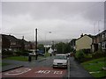
A grey day!
Looking NE down Sandy Lane, Dukinfield on a wet day. This part of Sandy Lane occupies the extreme NW corner of the grid square. The road bends to the left as it drops into the valley of the River Tame and crosses the river. The houses on the left and those just out of shot on the right were built in the 1970's on land identified as "Old Sand Pits" on the 1907 OS maps. Taken from SJ95039793.
Image: © Keith Williamson
Taken: 29 Aug 2005
0.02 miles
2
Sandy Vale
Large house on Sandy Lane.
Image: © Gerald England
Taken: 11 Feb 2011
0.07 miles
3
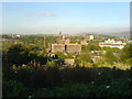
Tame Valley
Looking roughly northeast and out of this gridsquare from above an area of open space known as Sandhills, close to Dukinfield Cemetery. Tower Mill, a former cotton mill, is prominent in the centre. This mill is located on Park Road, Dukinfield on the banks of the River Tame.
Image: © Keith Williamson
Taken: 5 Oct 2007
0.08 miles
4
Oxford Road, Dukinfield
Looking along Oxford Road from St John Street.
Image: © Keith Williamson
Taken: 15 Sep 2007
0.09 miles
5

Dukinfield
Looking along Oxford Road towards Stalybridge. The hill in the centre distance is Harridge Pike in SJ9999.
Image: © Keith Williamson
Taken: 15 Sep 2007
0.09 miles
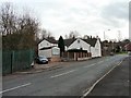
6
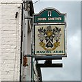
Sign of the Masons Arms
Sign for the Masons Arms Image
Image: © Gerald England
Taken: 11 Aug 2014
0.09 miles
7
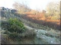
Frost on The Sandhills by Pantomime Steps
Frost lingering on after a cold night. Looking towards Pantomime Steps from The Sandhills. Houses on Harold Avenue and the exit from Dukinfield Cemetery visible at top left.
Image: © Keith Williamson
Taken: 20 Dec 2007
0.10 miles
8
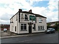
Masons Arms
A John Smith's pub on Oxford Road.
Image
Image: © Gerald England
Taken: 11 Aug 2014
0.10 miles
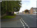
9
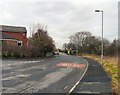
Prospect Road
The exit road from Dukinfield cemetery.
Image: © Gerald England
Taken: 11 Feb 2011
0.10 miles
10
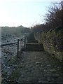
Pantomime Steps
Sets of old cobbled steps, rising about 30 metres, linking Tower Street and Prospect Road. These steps divide Dukinfield Cemetery (to the right) from an area of open public space known as The Sandhills.
Image: © Keith Williamson
Taken: 20 Dec 2007
0.10 miles