IMAGES TAKEN NEAR TO
Port Vale, HERTFORD, SG14 3AA
Introduction
This page details the photographs taken nearby to Port Vale, SG14 3AA by members of the Geograph project.
The Geograph project started in 2005 with the aim of publishing, organising and preserving representative images for every square kilometre of Great Britain, Ireland and the Isle of Man.

There are currently over 7.5m images from over14,400 individuals and you can help contribute to the project by visiting https://www.geograph.org.uk
Image Map
Images are licensed for reuse under creativecommons.org/licenses/by-sa/2.0
Notes
- Clicking on the map will re-center to the selected point.
- The higher the marker number, the further away the image location is from the centre of the postcode.
Image Listing (169 Images Found)
Images are licensed for reuse under creativecommons.org/licenses/by-sa/2.0
Image
Details
Distance
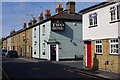
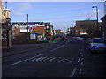
2
Cowbridge, Hertford
Cowbridge seen from the bottom of Port Hill. Chambers Street is on the left and the white building on the left in the background is part of McMullen's brewery.
Image: © Rob Candlish
Taken: 23 Aug 2010
0.06 miles
4
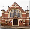
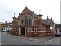
Hertford Baptist Church
Grade II listed church built to the designs of George Baines and Sons in 1906. Extensive architectural description at this https://historicengland.org.uk/listing/the-list/list-entry/1268923.
Image: © Jim Osley
Taken: 11 Aug 2016
0.07 miles
6
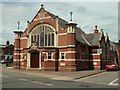
Hertford Baptist Church
It was built in 1906-7 and stands at Port Hill, which is the B158.
Image: © Robert Edwards
Taken: 6 May 2009
0.07 miles
7
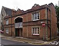
Prince Albert model cottages, Hertford
For the Great Exhibition of 1851 the architect Henry Roberts design a pair of model cottages. These were eventually re-located to Kennington. The design was replicated at Hertford. More at this https://en.wikipedia.org/wiki/List_of_existing_model_dwellings. For the Kennington cottages see this http://www.geograph.org.uk/photo/3817716.
Image: © Jim Osley
Taken: 11 Aug 2016
0.08 miles
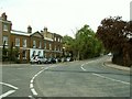
8
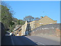
Bridge in Port Hill, SG14
I think that this may have crossed the old railway line from Hertford East to Hertford North; houses have now been built on the land on either side of the road.
Image: © Mike Quinn
Taken: 23 Apr 2015
0.08 miles
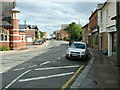
9
Cowbridge, Hertford
The road crosses the bridge over the river by the red car half way along.
Image: © David Howard
Taken: 7 Feb 2009
0.10 miles
10
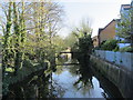
The River Beane east of Port Hill, SG14
Looking upstream.
Image: © Mike Quinn
Taken: 23 Apr 2015
0.11 miles