IMAGES TAKEN NEAR TO
Currie Street, HERTFORD, SG13 7DB
Introduction
This page details the photographs taken nearby to Currie Street, SG13 7DB by members of the Geograph project.
The Geograph project started in 2005 with the aim of publishing, organising and preserving representative images for every square kilometre of Great Britain, Ireland and the Isle of Man.

There are currently over 7.5m images from over14,400 individuals and you can help contribute to the project by visiting https://www.geograph.org.uk
Image Map
Images are licensed for reuse under creativecommons.org/licenses/by-sa/2.0
Notes
- Clicking on the map will re-center to the selected point.
- The higher the marker number, the further away the image location is from the centre of the postcode.
Image Listing (35 Images Found)
Images are licensed for reuse under creativecommons.org/licenses/by-sa/2.0
Image
Details
Distance
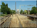
1
Old level crossing, Mead Lane
This was for King's Mead siding, serving the gas works. It was arranged to be most easily reached from the Hertford East - Hertford North (GE to GN) link line, now gone.
Image: © Robin Webster
Taken: 21 Aug 2015
0.07 miles
2
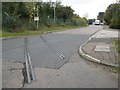
Hertford: Mead Lane
The short section of railway track across the road is a remnant of a siding that used to run from the railway at Hertford East station to near the gasworks and to near Hertford Lock on the River Lee Navigation.
Image: © Nigel Cox
Taken: 14 Oct 2009
0.08 miles

4
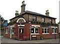
Hertford: The Saracen's Head
This pub with its elaborate entrance fascia, at the junction of Ware Road and Railway Place, has an interesting history. It was probably built as an ordinary house as the area north of Ware Road was developed on the building of the original Hertford East railway terminus at the end of the street in the 1840s. It seems to have been rapidly converted into a public house, with the ground floor extensions visible in the photo being built at that time, to live off the trade generated by railway users.
It is a Grade II Listed Building.
Image: © Nigel Cox
Taken: 29 Oct 2010
0.11 miles
5
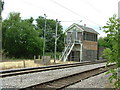
Old signal box, Hertford East
Hertford East signal box was made redundant when signalling for the branch line was centralised at Liverpool Street in London under the West Anglia Route Modernisation scheme (known by the acronym "WARM" to railwaymen).
Unlike the 1960s signal box at Ware (the next station down the line), which has now been demolished, Hertford East's box continues to stand derelict and unrepainted for years as something of an eyesore at this end of the town.
Image: © Rob Candlish
Taken: 26 Jul 2010
0.12 miles
6
Redundant signal box. Hertford East
The redundant signal box and carriage sidings at Hertford East Station seen from the end of platform one.
Image: © Rob Candlish
Taken: 9 Aug 2010
0.13 miles
7

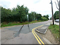
A119 Ware Road, Hertford
Heading towards Ware.
Image: © Robin Webster
Taken: 17 Feb 2019
0.13 miles
8
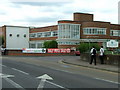
Ware Road, Hertford
Part of the former Addis brush factory, now the offices of the local newspaper.
Image: © Rob Candlish
Taken: 12 Jul 2010
0.13 miles

10
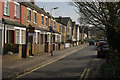
Townshend Street, Hertford
Residential street conveniently close to Hertford East station.
Image: © Stephen McKay
Taken: 28 Mar 2011
0.14 miles