IMAGES TAKEN NEAR TO
Lime Close, WARE, SG12 7ND
Introduction
This page details the photographs taken nearby to Lime Close, SG12 7ND by members of the Geograph project.
The Geograph project started in 2005 with the aim of publishing, organising and preserving representative images for every square kilometre of Great Britain, Ireland and the Isle of Man.

There are currently over 7.5m images from over14,400 individuals and you can help contribute to the project by visiting https://www.geograph.org.uk
Image Map (Loading...)


Getting Data...Please wait
Leaflet Map data © OpenStreetMap
Images are licensed for reuse under creativecommons.org/licenses/by-sa/2.0
Notes
- Clicking on the map will re-center to the selected point.
- The higher the marker number, the further away the image location is from the centre of the postcode.
Image Listing (14 Images Found)
Images are licensed for reuse under creativecommons.org/licenses/by-sa/2.0
Image
Details
Distance
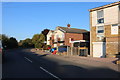
1
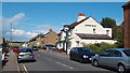
Musley Hill, Ware
Climbing out of the Lea Valley past the Rifle Volunteer pub, near left.
Image: © Robin Webster
Taken: 17 Feb 2019
0.03 miles
2
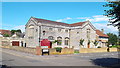
Musley School
The former Musley School seen from the junction of Homefield Road and Musley Hill. Hertfordshire County Council still own the building but seem undecided about what to do with it. Consequently it continues to deteriorate despite its Grade II listed status.
Image: © Rob Candlish
Taken: 11 Aug 2010
0.09 miles
3
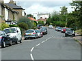
Trinity Road from its junction with Musley Lane
A view along Trinity Road, Ware looking towards Tower Road, the eponymous feature of which figures prominently in the background.
Image: © Rob Candlish
Taken: 11 Aug 2010
0.13 miles
4
Ware: The Bourne
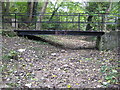
A bourne is an intermittent stream that only flows when the level of the water table in the ground reaches the surface or when there has been sufficient rainfall to saturate the surrounding land. Most have prefixed names such as "Winter Bourne", but this one is just The Bourne, and the watercourse only runs for a couple of kilometres before joining the River Lee in Ware. At the end of October 2010 the stream bed was totally dry.
Here a footbridge takes the path between Milton Road and Southall Close across the dry stream bed.
Image: © Nigel Cox
Taken: 29 Oct 2010
0.15 miles
6
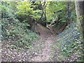
Ware: The Bourne
A bourne is an intermittent stream that only flows when the level of the water table in the ground reaches the surface or when there has been sufficient rainfall to saturate the surrounding land. Most have prefixed names such as "Winter Bourne", but this one is just The Bourne, and the watercourse only runs for a couple of kilometres before joining the River Lee in Ware. At the end of October 2010 the stream bed was totally dry.
It runs here in an incised wooded valley that is quite deep, about 5 metres, compared to the reach just a couple of hundred metres further upstream Image
Image: © Nigel Cox
Taken: 29 Oct 2010
0.16 miles
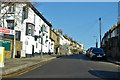
7
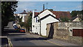
The Crooked Billet, Ware
The Crooked Billet pub in Ware, Hertfordshire.
Image: © Malc McDonald
Taken: 3 Aug 2013
0.17 miles
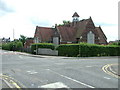
8
Catholic Church, Ware
The Church of the Sacred Heart of Jesus and St. Joseph, a Roman Catholic church in Ware.
Image: © Malc McDonald
Taken: 3 Aug 2013
0.18 miles
9
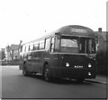
Fanhams Road, Ware
London Country RF604 (NLE604) a 1953 Metro-Cammell bodied AEC Regal IV in Fanhams Road on Hertford and Ware town service route 395A. The junction with Cundalls Road is immediately behind the bus.
The incorrect chalked destination display reading simply "395" seems to indicate that the correct blind could not be found by Hertford Garage. When this photograph was taken route 395A was only operated by single deckers on Sundays, for the rest of the week it was a double deck route.
Image: © Rob Candlish
Taken: Unknown
0.20 miles