IMAGES TAKEN NEAR TO
Green Lane, WARE, SG11 2QW
Introduction
This page details the photographs taken nearby to Green Lane, SG11 2QW by members of the Geograph project.
The Geograph project started in 2005 with the aim of publishing, organising and preserving representative images for every square kilometre of Great Britain, Ireland and the Isle of Man.

There are currently over 7.5m images from over14,400 individuals and you can help contribute to the project by visiting https://www.geograph.org.uk
Image Map
Images are licensed for reuse under creativecommons.org/licenses/by-sa/2.0
Notes
- Clicking on the map will re-center to the selected point.
- The higher the marker number, the further away the image location is from the centre of the postcode.
Image Listing (92 Images Found)
Images are licensed for reuse under creativecommons.org/licenses/by-sa/2.0
Image
Details
Distance
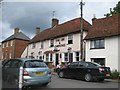
2
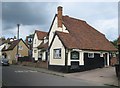
Braughing: The Brown Bear
As with Image The Brown Bear was once a 16th century timber-framed roughcast house, since converted into a public house. The 1878 Ordnance Survey map shows it as The Bear, but, by the time that the 1897 edition was printed, it had acquired its current name. It is a Grade II* Listed Building.
Image: © Nigel Cox
Taken: 19 Jun 2011
0.11 miles
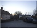
3
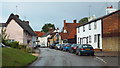
The Street, Braughing
The Brown Bear pub visible in the distance
Image: © Bikeboy
Taken: 25 Mar 2016
0.11 miles
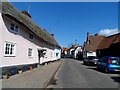
4
Braughing: The Habit and The Gatehouse
The Habit, to the left, and The Gatehouse, to the right, are a couple of timber framed roughcast Grade II Listed Buildings dating from the 16th century. The Habit with its four windows set either side of the door and the large chimney is a former hall-house, while The Gatehouse, with its pair of jettied first floor gables, is described on the English Heritage website as having had a drastic restoration in the 1950s.
Image: © Nigel Cox
Taken: 19 Jun 2011
0.14 miles
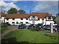
7
Braughing: The Axe and Compasses
Continuing on to the left from Image this pub was once a house, bucking the present day trend. It is thought that the name might derive from meetings of The Worshipful Company of Carpenters held here around 1800. Certainly up to 1921 the Ordnance Survey were showing the pub as The Axe and Compass, singular. This is yet again, like so many in Braughing, a Grade II Listed Building.
Image: © Nigel Cox
Taken: 19 Jun 2011
0.15 miles
8
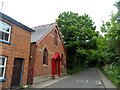
Methodist chapel, Braughing
Seems to still be in use as a chapel.
Image: © Bikeboy
Taken: 25 May 2015
0.17 miles
9
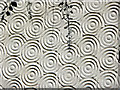
Unusual rendering on house in Braughing
See Image] for image of house.
Image: © Christine Matthews
Taken: 23 May 2010
0.17 miles
10
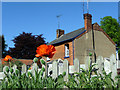
Cottage, Braughing
Early flowering poppies with cottage in background.
Image: © Christine Matthews
Taken: 23 May 2010
0.18 miles