IMAGES TAKEN NEAR TO
Naomi Street, LONDON, SE8 5EW
Introduction
This page details the photographs taken nearby to Naomi Street, SE8 5EW by members of the Geograph project.
The Geograph project started in 2005 with the aim of publishing, organising and preserving representative images for every square kilometre of Great Britain, Ireland and the Isle of Man.

There are currently over 7.5m images from over14,400 individuals and you can help contribute to the project by visiting https://www.geograph.org.uk
Image Map
Images are licensed for reuse under creativecommons.org/licenses/by-sa/2.0
Notes
- Clicking on the map will re-center to the selected point.
- The higher the marker number, the further away the image location is from the centre of the postcode.
Image Listing (113 Images Found)
Images are licensed for reuse under creativecommons.org/licenses/by-sa/2.0
Image
Details
Distance
1
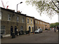
Croft Street, Deptford
A contrast between the older housing on Croft Street and the newer development of Woodcroft Mews behind security gates.
Image: © Stephen Craven
Taken: 19 Apr 2014
0.07 miles
2
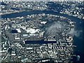
Rotherhithe from the air
Greenland Dock is prominent in the centre. Taken from a Heathrow bound flight from Glasgow.
Image: © Thomas Nugent
Taken: 18 Mar 2014
0.08 miles
3

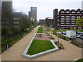
Rainsborough Avenue
The embankment and bridge abutment are the remains of the Deptford Wharf branch line. A freight only route to the docks that closed in 1964
Image: © Robert Eva
Taken: 10 Jan 2016
0.09 miles
4
Course of Grand Surrey Canal
Looking towards where it entered the Surrey Docks.
Image: © Robin Webster
Taken: 6 Apr 2019
0.10 miles
5
Industrial plant, Croft Street, Deptford
I have not been able to find out which business this plant belongs to or what it is for.
Image: © Stephen Craven
Taken: 19 Apr 2014
0.10 miles
6
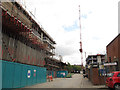
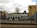
Yeoman Street, Deptford
Construction sites on both sides of the street.
Image: © Stephen Craven
Taken: 19 Apr 2014
0.11 miles
7
Rainsborough Avenue, Deptford
Behind the sheeting a Barratt housing development was just starting. The trees behind are growing on the embankment that once carried a railway into Deptford Wharf (closed 1964).
Image: © Stephen Craven
Taken: 19 Apr 2014
0.11 miles
9
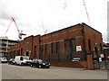
Earl Pumping Station, Chilton Grove, Deptford
This building is not listed, perhaps surprisingly given its historical significance. It is a sewage pumping station, lifting water out of what was historically called the Earl Sluice - a river or drainage ditch running from Denmark Hill to the Thames near here - but since the 19th century a public sewer, into the Southern Outfall Sewer running towards Crossness. More detailed history at http://marlowe-shakespeare.blogspot.co.uk/2012/07/getting-body-to-deptford-by-peter-farey.html
An overflow takes surplus storm sewage into the Thames nearby, probably using the original course of the river. As of 2014 it is proposed to use the site for a major construction site for a "drop shaft" taking the waters of the Earl Sluice into the Thames Tideway, 30m or more deep under the Thames.
The Earl Sluice was historically the boundary between Rotherhithe (Surrey) and Deptford (Kent) ecclesiastical and civil parishes, hence a county boundary. Chilton Grove (foreground) follows the course of the former sluice, and is still on the civil boundary between Southwark and Lewisham boroughs - see Image - but the present ecclesiastical boundary between Holy Trinity, Rotherhithe and St Nicholas & St Luke, Deptford runs behind the pumping station.
Image: © Stephen Craven
Taken: 19 Apr 2014
0.12 miles
10
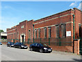
Earl Pumping Station, Chilton Grove
With modest Deco touches.
Now operated by Thames Water. More info: Image
Image: © Stephen Richards
Taken: 26 May 2013
0.12 miles