IMAGES TAKEN NEAR TO
Adolphus Street, LONDON, SE8 4LU
Introduction
This page details the photographs taken nearby to Adolphus Street, SE8 4LU by members of the Geograph project.
The Geograph project started in 2005 with the aim of publishing, organising and preserving representative images for every square kilometre of Great Britain, Ireland and the Isle of Man.

There are currently over 7.5m images from over14,400 individuals and you can help contribute to the project by visiting https://www.geograph.org.uk
Image Map
Images are licensed for reuse under creativecommons.org/licenses/by-sa/2.0
Notes
- Clicking on the map will re-center to the selected point.
- The higher the marker number, the further away the image location is from the centre of the postcode.
Image Listing (256 Images Found)
Images are licensed for reuse under creativecommons.org/licenses/by-sa/2.0
Image
Details
Distance
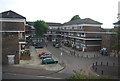
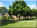
2
Margaret Macmillan Park, redeveloped (2)
This is essentially the same view as Image in 2006. The linear park along the line of Douglas Way was redeveloped in the first half of 2010.
Image: © Stephen Craven
Taken: 28 May 2010
0.07 miles
3
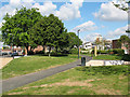
Margaret Macmillan Park, redeveloped (3)
This park was redeveloped in the first half of 2010. A view looking from the southern end of Warwickshire Path. The tower in the distance is the Hawke Tower Image
Image: © Stephen Craven
Taken: 28 May 2010
0.08 miles
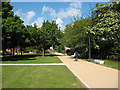
4
Margaret Macmillan Park, Deptford
One of several green spaces left in the redevelopment of Deptford. This path is part of the London Cycle Network.
Image: © Stephen Craven
Taken: 15 Oct 2006
0.08 miles
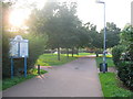
5
Margaret Macmillan Park, redeveloped (1)
The park was redeveloped by Lewisham Council in the first half of 2010. This is the eastern end of the park adjacent to Douglas Way. The purpose of the different height wooden posts is unclear.
Image: © Stephen Craven
Taken: 28 May 2010
0.09 miles
6

Deptford market, Douglas Way
There is a market at the east end of Douglas Way on Wednesdays and Fridays, but on Saturdays it stretches the full length of the street.
Image: © Stephen Craven
Taken: 10 Dec 2011
0.09 miles
7
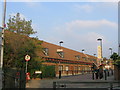
Albany Theatre, Deptford
A modern theatre and community centre just off Deptford High Street.
Image: © Stephen Craven
Taken: 15 Oct 2006
0.10 miles
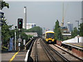
9
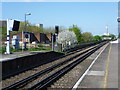
Deptford station
Deptford station came into existence when the London & Greenwich Railway opened its first section between Spa Road,Bermondsey and Deptford on 8th February 1836. Opened at the same time, Deptford station is reputedly the oldest railway station in London, and the oldest suburban station in the world, to survive on its existing site. The line was extended westwards to the new London Bridge station on 14th December 1836 and eastwards to Greenwich on 24th December 1838. The line is carried on a viaduct of 878 brick arches between London Bridge and Greenwich.
Deptford station was closed between 1915 and 1926. The original station building was demolished by the Southern Railway and the current station building constructed in its place. A new station building was opened in 2012 which is fully accessible with lifts from the street level and glass enclosing new stairs.
This view from the down platform looks back along the viaduct in the direction of London Bridge station.
Image: © Marathon
Taken: 13 Apr 2014
0.11 miles
10
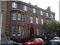
Old Deptford Police Station on Amersham Vale, New Cross
This building is now being used as artists studios and a police museum. It also houses opticalradio.com, a community radio station. The new police station is next door.
Image: © David Lunn
Taken: 30 Sep 2010
0.11 miles