IMAGES TAKEN NEAR TO
Adenmore Road, LONDON, SE6 4BS
Introduction
This page details the photographs taken nearby to Adenmore Road, SE6 4BS by members of the Geograph project.
The Geograph project started in 2005 with the aim of publishing, organising and preserving representative images for every square kilometre of Great Britain, Ireland and the Isle of Man.

There are currently over 7.5m images from over14,400 individuals and you can help contribute to the project by visiting https://www.geograph.org.uk
Image Map
Images are licensed for reuse under creativecommons.org/licenses/by-sa/2.0
Notes
- Clicking on the map will re-center to the selected point.
- The higher the marker number, the further away the image location is from the centre of the postcode.
Image Listing (220 Images Found)
Images are licensed for reuse under creativecommons.org/licenses/by-sa/2.0
Image
Details
Distance

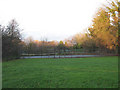
2
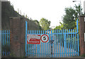
No more dog racing
The gate across the track to Image shows that this is now a construction site, though redevelopment has not yet started.
Image: © Stephen Craven
Taken: 8 Jun 2008
0.04 miles
3
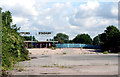
Catford: The entrance to the derelict dog track
Catford Stadium closed years ago but nothing has been done to re-use the site, which I believe belongs to Lewisham Council. I had to take this shot with a very long lens poked through a security fence, as the 'jobsworth' on duty refused to unlock the barrier to enable me to get closer.
Image: © Dr Neil Clifton
Taken: 23 Aug 2012
0.05 miles
4
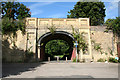
Catford: Access from Adenmore road to Ladywell Recreation Ground
As can be seen, motor vehicles are not able to make use of this route under a bridge on the Catford Loop railway line; probably few pedestrians do either, but cyclists probably do, as it links with a well-used south-north cycle route.
Image: © Dr Neil Clifton
Taken: 23 Aug 2012
0.05 miles
5
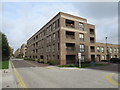
Adenmore Road, Catford
Recently-built apartment blocks on Adenmore Road in Catford, in south east London.
Image: © Malc McDonald
Taken: 20 Oct 2019
0.05 miles
6
Tennis courts, Ladywell Fields
The courts are physically adjacent to the bowling green Image but approached from a different direction.
For a photo in 2011 after the area had been improved, see Image
Image: © Stephen Craven
Taken: 26 Dec 2009
0.05 miles
7
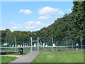
Tennis and bowls
Tennis courts and bowling green in Ladywell Fields well used on a warm Sunday afternoon.
The path in the foreground has been added as part of the 2011 improvements to the park. For a "before" shot see Image
Image: © Stephen Craven
Taken: 24 Jul 2011
0.05 miles
8
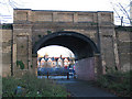
Railway bridge no. 469, Catford
The bridge takes the Blackfriars-Bromley railway (the "Catford Loop" line) over a footpath that leads from Adenmore Road into Ladywell Fields. The Network Rail plaque giving its number also gives its chainage (distance) as 7 miles 75 chains [from Victoria].
Image: © Stephen Craven
Taken: 26 Dec 2009
0.06 miles
9
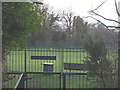
Ladywell Bowling Club
This was the closest shot I could get, through a high outer security gate.
Image: © Stephen Craven
Taken: 26 Dec 2009
0.06 miles
10
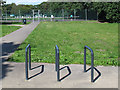
Cycle stand at southern end of Ladywell Fields
The stand had recently been introduced to serve the nearby sports facilities Image
Image: © Stephen Craven
Taken: 24 Jul 2011
0.06 miles