IMAGES TAKEN NEAR TO
Arnulf Street, LONDON, SE6 3EF
Introduction
This page details the photographs taken nearby to Arnulf Street, SE6 3EF by members of the Geograph project.
The Geograph project started in 2005 with the aim of publishing, organising and preserving representative images for every square kilometre of Great Britain, Ireland and the Isle of Man.

There are currently over 7.5m images from over14,400 individuals and you can help contribute to the project by visiting https://www.geograph.org.uk
Image Map
Images are licensed for reuse under creativecommons.org/licenses/by-sa/2.0
Notes
- Clicking on the map will re-center to the selected point.
- The higher the marker number, the further away the image location is from the centre of the postcode.
Image Listing (36 Images Found)
Images are licensed for reuse under creativecommons.org/licenses/by-sa/2.0
Image
Details
Distance
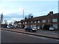
1
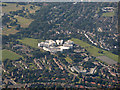
Bellingham from the air
Sedgehill School is prominent in the centre, with the smaller Watergate School in the right foreground.
Sedgehill web site: http://www.sedgehillschool.co.uk .
Watergate web site: http://www.watergate.lewisham.sch.uk/ .
Image: © Thomas Nugent
Taken: 26 Aug 2019
0.06 miles
2
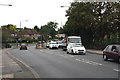
Bellingham: Southend Lane
Looking west from the bridge over the Catford Loop railway line. This is the A2218. It is not the South Circular Road, but it might as well be, because a large number of drivers find that this is a better route, and use it instead, which means that Southend Lane is a very busy road. 'Lane' it certainly is not. If you looked at a very old map you might find that, two hundred or so years ago, it was really a lane.
Image: © Dr Neil Clifton
Taken: 30 Aug 2012
0.10 miles
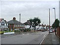
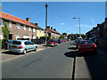
3
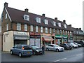
Shopping Parade, Dunfield Road, Bellingham
Image: © Chris Whippet
Taken: 11 Aug 2015
0.10 miles
4
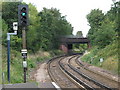
Railway lines north of Beckenham Hill station
Image: © Mike Quinn
Taken: 4 Sep 2009
0.12 miles
5
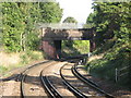
Bridge for Southend Lane (A2218) north of Beckenham Hill station
Image: © Mike Quinn
Taken: 8 Oct 2009
0.13 miles
6
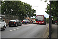
Bellingham: Southend Lane
Looking east along the always-busy A2218 just where it passes the bridge over the Catford Loop railway. The bus is on Route 181 which operates from Grove Park to Lewisham via Lower Sydenham.
Image: © Dr Neil Clifton
Taken: 30 Aug 2012
0.13 miles
8
Elfrida Crescent SE6
Note stone cladding on the house just to the left of the telegraph pole.
Image: © Philip Talmage
Taken: 29 Aug 2005
0.16 miles