IMAGES TAKEN NEAR TO
Ringstead Road, LONDON, SE6 2BT
Introduction
This page details the photographs taken nearby to Ringstead Road, SE6 2BT by members of the Geograph project.
The Geograph project started in 2005 with the aim of publishing, organising and preserving representative images for every square kilometre of Great Britain, Ireland and the Isle of Man.

There are currently over 7.5m images from over14,400 individuals and you can help contribute to the project by visiting https://www.geograph.org.uk
Image Map
Images are licensed for reuse under creativecommons.org/licenses/by-sa/2.0
Notes
- Clicking on the map will re-center to the selected point.
- The higher the marker number, the further away the image location is from the centre of the postcode.
Image Listing (28 Images Found)
Images are licensed for reuse under creativecommons.org/licenses/by-sa/2.0
Image
Details
Distance
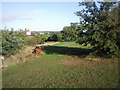
1
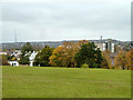
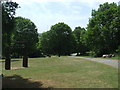
View from Mountsfield Park
Looking over the Ravensbourne valley.
Image: © Robin Webster
Taken: 30 Oct 2011
0.05 miles
2
View from Mountsfield Park
Looking over the Ravensbourne valley.
Image: © Robin Webster
Taken: 30 Oct 2011
0.09 miles
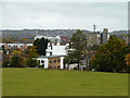
3

Brownhill Road, Catford
The South Circular Road is remarkably quiet here.
Image: © Bill Boaden
Taken: 11 Oct 2014
0.14 miles
4
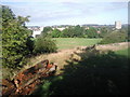
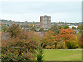
Mountsfield Park
Mountsfield Park is higher along its eastern side and then drops down to the west side. This gives fine views to the west as here. The wooded hill to the left of the tower block is One Tree Hill at Honor Oak.
Image: © Marathon
Taken: 24 Aug 2010
0.16 miles
5
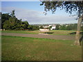
View from Mountsfield Park
Mountsfield Park in Catford slopes down to the west, so there are fine views in that direction. The Crystal Palace TV transmitter is on the skyline, just to the left of the seat. The dip in the horizon to the right of the seat is where the Horniman Museum at Forest Hill is to be found.
Image: © Marathon
Taken: 24 Aug 2010
0.17 miles
6
Mountsfield Park, Catford
Mountsfield Park in Catford, South East London. In the far distance, behind the trees, the TV transmitter mast at Crystal Palace is just visible.
Image: © Malc McDonald
Taken: 25 May 2011
0.17 miles
7
Capital House
47 Rushley Green, seen from Mountsfield Park.
Image: © Robin Webster
Taken: 30 Oct 2011
0.18 miles
8
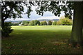
Mountsfield Park
Looking west towards Catford.
Image: © Bill Boaden
Taken: 11 Oct 2014
0.18 miles
9
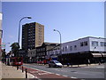
Rushey Green Catford
Rushey Green is the A26
Image: © PAUL FARMER
Taken: 31 May 2009
0.19 miles
10
Mountsfield Park
A fairly steep slope runs north south through the centre of Mountsfield Park. The west side of the park is lower than the east. Shrubs and trees lie along much of the slope as seen to the left of the rotting log. The wooded hill on the horizon to the right of the tower block is Nunhead Cemetery.
Image: © Marathon
Taken: 24 Aug 2010
0.19 miles