IMAGES TAKEN NEAR TO
Camberwell Green, LONDON, SE5 7PR
Introduction
This page details the photographs taken nearby to Camberwell Green, SE5 7PR by members of the Geograph project.
The Geograph project started in 2005 with the aim of publishing, organising and preserving representative images for every square kilometre of Great Britain, Ireland and the Isle of Man.

There are currently over 7.5m images from over14,400 individuals and you can help contribute to the project by visiting https://www.geograph.org.uk
Image Map (262 Images)


Getting Data...Please wait
Leaflet Map data © OpenStreetMap
Images are licensed for reuse under creativecommons.org/licenses/by-sa/2.0
Notes
- Clicking on the map will re-center to the selected point.
- The higher the marker number, the further away the image location is from the centre of the postcode.
Image Listing (262 Images Found)
Images are licensed for reuse under creativecommons.org/licenses/by-sa/2.0
Image
Details
Distance
1
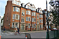
Park House and Brighton House, north end of Camberwell Green
These first appear on an OS map of 1916, replacing small properties. They are not part of the Peabody estate that adjoins them. They appear to be privately owned and let flats.
Image: © Robin Stott
Taken: 18 Sep 2015
0.01 miles
2
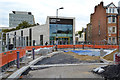
The new Camberwell Library and the reconstruction of Camberwell Green, the road
It's due to open in November, I was told by a librarian leaving the site. The existing library is in Camberwell Church Street: Image In the left background are offices adjoining Camberwell Green Magistrates Court and Youth Court. On the right is D'Eynsford Road and half of Park House. It is not part of the neighbouring Peabody estate but appears to be private flats.
Image: © Robin Stott
Taken: 18 Sep 2015
0.02 miles
4
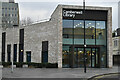
Camberwell Library
Modern library at the northeastern corner of Camberwell Green.
Image: © David Martin
Taken: 29 Jan 2023
0.02 miles
5
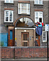
Peabody Estate, Camberwell Green, entrance to Block K
This building dates from 1911 and is seen in Image
Image: © Robin Stott
Taken: 18 Sep 2015
0.02 miles
6
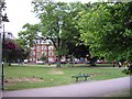
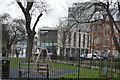
Camberwell Green
Looking toward D'Eynsford Road. The buildings to the left of the central tree are Brighton and Park Houses.
Image: © PAUL FARMER
Taken: 25 May 2009
0.02 miles
7
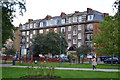
Peabody Estate, Camberwell Green, flats built in 1920
Note the architect's faint classical touches above the cornice. There are three blocks within the building, one of which is Block K. There are modern porches in front of the original arched entrances: Image Note the balconies, not provided in the 1911 buildings. There is a second building behind this one. Of the three buildings seen on the east side of Camberwell Green this is the middle one. To the south (right) is the front one of the three built in 1911, blocks A, B and C: Image and Mike Faherty's Image
Image: © Robin Stott
Taken: 18 Sep 2015
0.03 miles
8
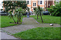
Second World War memorials, Camberwell Green, London
At the north end of Camberwell Green is this Y-shaped area of paving off the main path. It's the setting for two memorials to people killed during World War II. That on the right is a general memorial: Image That in the centre relates to Camberwell and a number of individuals sadly killed: Image
Image: © Robin Stott
Taken: 19 Sep 2015
0.03 miles
9
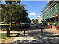
Camberwell Green, the road, is now a cul-de-sac, Camberwell, south London
The north end of the street is now for car parking on both sides. The newly-paved south end is in effect an extension of the Camberwell Green open space, a much-loved pocket park, giving residents of the Peabody tenements, right, some sunny outside space.
Image: © Robin Stott
Taken: 29 Aug 2016
0.03 miles
10
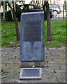
Memorial to Camberwell people who died or suffered in war, Camberwell Green, London
This is one of two memorials at the north end of Camberwell Green to people killed in war: Image
The inscriptions on the vertical element read:
In memory of the people of Camberwell who died or suffered in War
This memorial stands above the Air Raid Shelter where a wedding party lost their lives on the afternoon of 17 September 1940.
Sidney and Patricia Wright had just married and were celebrating in the nearby 'Mother Redcap' public house with family and friends.
During an air raid, they sought refuge in the shelter which was directly hit by a bomb. All members of the Wright family and four other people were killed.
May they, and all victims of War, rest in peace.
The plaque on the ground lists the bodies recovered from the shelter the next day: http://www.geograph.org.uk/photo/4794740.
Image: © Robin Stott
Taken: 19 Sep 2015
0.03 miles