IMAGES TAKEN NEAR TO
New Church Road, LONDON, SE5 7JJ
Introduction
This page details the photographs taken nearby to New Church Road, SE5 7JJ by members of the Geograph project.
The Geograph project started in 2005 with the aim of publishing, organising and preserving representative images for every square kilometre of Great Britain, Ireland and the Isle of Man.

There are currently over 7.5m images from over14,400 individuals and you can help contribute to the project by visiting https://www.geograph.org.uk
Image Map (Loading...)


Getting Data...Please wait
Leaflet Map data © OpenStreetMap
Images are licensed for reuse under creativecommons.org/licenses/by-sa/2.0
Notes
- Clicking on the map will re-center to the selected point.
- The higher the marker number, the further away the image location is from the centre of the postcode.
Image Listing (158 Images Found)
Images are licensed for reuse under creativecommons.org/licenses/by-sa/2.0
Image
Details
Distance
1
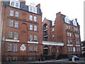
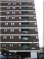
Evelina Mansions New Church Road Camberwell
The Industrial Dwellings Company Ltd built this block.
Image: © PAUL FARMER
Taken: 31 Jan 2010
0.03 miles
2
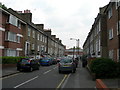
New Church Road, SE5
This is at the corner of Edmund Street and near the junction with Addington Square (see http://www.geograph.org.uk/photo/165917)
Image: © Danny P Robinson
Taken: 7 Jun 2006
0.03 miles
3
New Church Road, SE5 (2)
Sears Street http://www.geograph.org.uk/photo/182763 is the first road on the right, Evelina Mansions http://www.geograph.org.uk/photo/165920 is the furthest block of flats. Burgess Park http://www.geograph.org.uk/photo/182760 is out of shot on the left. View is towards Southampton Way. There was once a scrapyard on the site of the nearest block of flats (centre of shot). It gained some notoriety when it was owned by the Richardson brothers who used it as a base for their criminal activities. These included torturing business associates with whom they had fallen out.
Image: © Danny P Robinson
Taken: 12 Jul 2006
0.03 miles
4
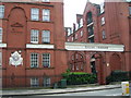
Evelina Mansions SE5
This is on Bowyer Place. The caption on the plaque reads "Four Per Cent Industrial Dwellings Company Ltd" which presumably indicated an interest rate, and the intended client group.
Image: © Danny P Robinson
Taken: 7 May 2006
0.04 miles
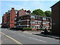
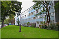
6
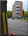
Admiral Court, north end of Lomond Grove, Camberwell
It's at the junction with Bowyer Place and New Church Road. The plane tree, left, has a little protection from construction traffic turning into the house-building site at the foot of Masterman House Image
Image: © Robin Stott
Taken: 18 Sep 2015
0.04 miles
7
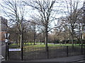
Addington Square Camberwell
The square is named after Henry Addington, Prime Minister from 1801 to 1804.
Image: © PAUL FARMER
Taken: 31 Jan 2010
0.05 miles
9
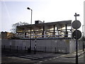
Derelict flats in New Church Road Camberwell
Image: © PAUL FARMER
Taken: 31 Jan 2010
0.05 miles
10
Rear of Caspian Street flats and maisonettes, Camberwell
Looking north from Lomond Grove.
Image: © Robin Stott
Taken: 18 Sep 2015
0.05 miles