IMAGES TAKEN NEAR TO
Chelwood Walk, LONDON, SE4 2QQ
Introduction
This page details the photographs taken nearby to Chelwood Walk, SE4 2QQ by members of the Geograph project.
The Geograph project started in 2005 with the aim of publishing, organising and preserving representative images for every square kilometre of Great Britain, Ireland and the Isle of Man.

There are currently over 7.5m images from over14,400 individuals and you can help contribute to the project by visiting https://www.geograph.org.uk
Image Map (Loading...)


Getting Data...Please wait
Leaflet Map data © OpenStreetMap
Images are licensed for reuse under creativecommons.org/licenses/by-sa/2.0
Notes
- Clicking on the map will re-center to the selected point.
- The higher the marker number, the further away the image location is from the centre of the postcode.
Image Listing (64 Images Found)
Images are licensed for reuse under creativecommons.org/licenses/by-sa/2.0
Image
Details
Distance
1
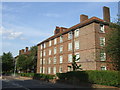
Flats on St Norbert Road, SE4
Local authority flats in Brockley.
Image: © Malc McDonald
Taken: 27 Jun 2010
0.05 miles
2
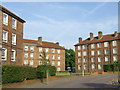
Honor Oak Estate
The Honor Oak Estate was built for the London County Council in the 1930s, passing to the London Borough of Lewisham when the Greater London Council was abolished in 1986.
Image: © Malc McDonald
Taken: 27 Jun 2010
0.06 miles
3
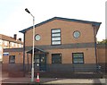
Honor Oak Health Centre
On Turnham Road.
Image: © David Anstiss
Taken: 25 Sep 2011
0.07 miles
4

Honor Oak Warden's Office, St Norbert Road SE4
Image: © Robin Sones
Taken: 19 Aug 2010
0.07 miles
5
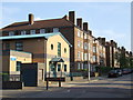
Honor Oak Health Centre
Health centre located in the Honor Oak Estate. The estate dates from the 1930s.
Image: © Malc McDonald
Taken: 27 Jun 2010
0.09 miles
6
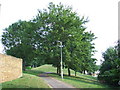
Route of the Crystal Palace High Level branch
The railway line from Nunhead to Crystal Palace High Level once passed through this point. The line was closed in 1954, and a housing development with landscaping occupies this part of the route.
Image: © Malc McDonald
Taken: 27 Jun 2010
0.09 miles

8
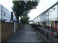
Aldersford Close, SE4
Housing built on the site of a disused railway. The branch line from Nunhead to Crystal Palace High Level passed this point, until its closure in 1954.
Image: © Malc McDonald
Taken: 27 Jun 2010
0.11 miles
9
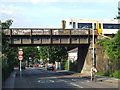
Railway bridge, St Norbert Road SE4
Bridge carrying the railway between Nunhead and Crofton Park stations, across St Norbert Road.
Image: © Malc McDonald
Taken: 27 Jun 2010
0.12 miles
