IMAGES TAKEN NEAR TO
Turnham Road, LONDON, SE4 2HU
Introduction
This page details the photographs taken nearby to Turnham Road, SE4 2HU by members of the Geograph project.
The Geograph project started in 2005 with the aim of publishing, organising and preserving representative images for every square kilometre of Great Britain, Ireland and the Isle of Man.

There are currently over 7.5m images from over14,400 individuals and you can help contribute to the project by visiting https://www.geograph.org.uk
Image Map
Images are licensed for reuse under creativecommons.org/licenses/by-sa/2.0
Notes
- Clicking on the map will re-center to the selected point.
- The higher the marker number, the further away the image location is from the centre of the postcode.
Image Listing (93 Images Found)
Images are licensed for reuse under creativecommons.org/licenses/by-sa/2.0
Image
Details
Distance
1
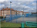
Hockey pitch, Brockley
Part of a set of games courts beside the London and Croydon Railway. On the left is Spalding House.
Image: © Derek Harper
Taken: 11 Mar 2011
0.02 miles
2
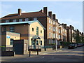
Honor Oak Health Centre
Health centre located in the Honor Oak Estate. The estate dates from the 1930s.
Image: © Malc McDonald
Taken: 27 Jun 2010
0.07 miles
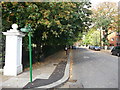
3
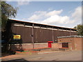
Honor Oak Youth Club
On Turnham Road.
Image: © David Anstiss
Taken: 25 Sep 2011
0.08 miles
4
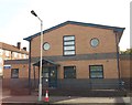
Honor Oak Health Centre
On Turnham Road.
Image: © David Anstiss
Taken: 25 Sep 2011
0.08 miles
5
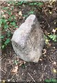
Old Boundary Marker
Railway Boundary Marker in Buckthorne Cutting Nature Reserve beside the line of the former London, Brighton and South Coast Railway. Access from Eddystone Road Footbridge, Eddystone Road, Brockley SE4 2DE, see https://www.fourthreserve.org.uk/. No inscription.
Milestone Society National ID: KE_LBSCR01em
Image: © Anna-Maria Cahalane
Taken: 2 Aug 2020
0.09 miles
6
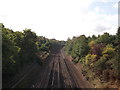
Railway line to Honor Oak Park
As seen from a footbridge between Dalrymple Road and Turnham Road.
The line leads from Brockley (and central London), towards Sydenham.
In the background is a footbridge between Eddystone Road to Brockley Way.
Image: © David Anstiss
Taken: 25 Sep 2011
0.10 miles
7
Brockley Way, SE4
In the northwestern corner of the square; the red flats ahead are in Image
Image: © Derek Harper
Taken: 11 Mar 2011
0.10 miles
8
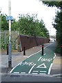
Green Chain Walk on Brockley Way
The long distance path leads left into Camberwell New Cemetery (and onwards to Honor Oak), it also heads straight along Brockley Way towards Nunhead Cemetery (and onwards to Nunhead Railway Station).
Image: © David Anstiss
Taken: 25 Sep 2011
0.12 miles
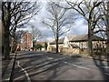
9
Cemetery gates, Brockley
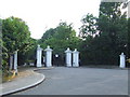
Entrance to Camberwell New Cemetery on Brockley Way.
Image: © Malc McDonald
Taken: 27 Jun 2010
0.13 miles
10
Railway bridge, Brockley
Pedestrian and cyclists' bridge linking Brockley Way with Eddystone Road.
Image: © Malc McDonald
Taken: 27 Jun 2010
0.13 miles