IMAGES TAKEN NEAR TO
Cypress Gardens, LONDON, SE4 2FB
Introduction
This page details the photographs taken nearby to Cypress Gardens, SE4 2FB by members of the Geograph project.
The Geograph project started in 2005 with the aim of publishing, organising and preserving representative images for every square kilometre of Great Britain, Ireland and the Isle of Man.

There are currently over 7.5m images from over14,400 individuals and you can help contribute to the project by visiting https://www.geograph.org.uk
Image Map
Images are licensed for reuse under creativecommons.org/licenses/by-sa/2.0
Notes
- Clicking on the map will re-center to the selected point.
- The higher the marker number, the further away the image location is from the centre of the postcode.
Image Listing (112 Images Found)
Images are licensed for reuse under creativecommons.org/licenses/by-sa/2.0
Image
Details
Distance
1
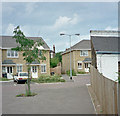
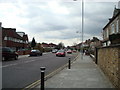
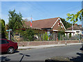
Brockley to Nunhead Footpath
The footpath commences on Brockley Road at the Brockley Jack (just out of shot on the right) and runs through Cypress Gardens. It can be seen passing to the left of the lamp standard and following a route between the two houses in the centre of the picture. It then crosses Buckthorne Road Image heading for the footbridge over the railway.
Image: © David Wright
Taken: 4 Sep 1998
0.01 miles
2
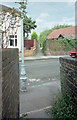
Brockley to Nunhead Footpath
The footpath commences at the Brockley Jack Image and passes through Cypress Gardens before crossing Buckthorne Road at an angle, as shown in the photo, heading for the footbridge over the railway.
Image: © David Wright
Taken: 7 Sep 1996
0.03 miles
3
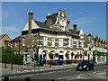
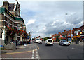
The Brockley Jack
An 1898 structure replacing an earlier building of the same name. When built, it sold 'Noakes Entire' according to an inscription on the black part of the end gable. This was a local brewery. It is now a Greene King pub. Its large function room, whose entrance is behind the black car, is now a theatre.
Image: © Robin Webster
Taken: 1 Oct 2011
0.04 miles
4
"Brockley Jack" public house and studio theatre (built 1898)
Image: © Jim Osley
Taken: 6 Nov 2014
0.04 miles
6
Brockley Jack SE4
The Brockley Jack dates from the eighteenth century and was formerly known as the Castle. It received its present name about 1863 and was rebuilt in 1898. Like many formerly rural, isolated pubs it is said to have been a haunt of highwaymen. Just visible beyond the pub is the Jack Theatre.
Image: © Philip Talmage
Taken: 26 Aug 2005
0.04 miles
7
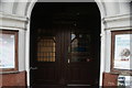
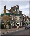
View of the entrance doors of the Brockley Jack pub from Brockley Road
Looking north-northwest.
Image: © Robert Lamb
Taken: 19 Aug 2018
0.04 miles
8
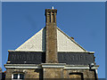
'Noakes Entire'
A memorial to a product of a long gone local brewery on the end of the Brockley Jack pub.
Image: © Robin Webster
Taken: 1 Oct 2011
0.04 miles
9
Royal British Legion, Brockley
The Beaufoy-Roberts Memorial Community Hall seen from the side and rear. The door is on the other side, on Eddystone Road.
Image: © Robin Webster
Taken: 1 Oct 2011
0.05 miles
10
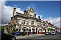
South London: The 'Brockley Jack'
Large and impressive Victorian public house on the B218. The date stone reads 1898, but it is likely that this is a rebuilding date, for it seems that this pub was at one time the haunt of highwaymen - the sign depicts one such. So it is not unreasonable to suppose that Brockley Jack himself followed this profession.
Image: © Dr Neil Clifton
Taken: 25 Aug 2012
0.05 miles