IMAGES TAKEN NEAR TO
Kidbrooke Park Road, LONDON, SE3 9NF
Introduction
This page details the photographs taken nearby to Kidbrooke Park Road, SE3 9NF by members of the Geograph project.
The Geograph project started in 2005 with the aim of publishing, organising and preserving representative images for every square kilometre of Great Britain, Ireland and the Isle of Man.

There are currently over 7.5m images from over14,400 individuals and you can help contribute to the project by visiting https://www.geograph.org.uk
Image Map
Images are licensed for reuse under creativecommons.org/licenses/by-sa/2.0
Notes
- Clicking on the map will re-center to the selected point.
- The higher the marker number, the further away the image location is from the centre of the postcode.
Image Listing (107 Images Found)
Images are licensed for reuse under creativecommons.org/licenses/by-sa/2.0
Image
Details
Distance
1
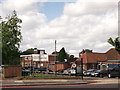
Joan Roan School Sports Pavilions
On Kidbrooke Park Road. Between two sports fields.
Image: © David Anstiss
Taken: 11 Sep 2011
0.01 miles
2
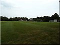
John Roan playing fields (1)
These are the playing fields of the John Roan secondary school Image in Westcombe Park a couple of miles away. Viewed from Sunnydale Road at the western side. There is evidence of use as an athletics track in the foreground, and on the far side is a cricket pavilion, seen closer up and from the other side in Image
Image: © Stephen Craven
Taken: 31 Jul 2014
0.01 miles
3
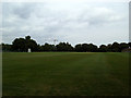
John Roan playing fields (2)
These are the playing fields of the John Roan secondary school Image in Westcombe Park a couple of miles away. Viewed from Sunnydale Road at the western side.
Image: © Stephen Craven
Taken: 31 Jul 2014
0.05 miles
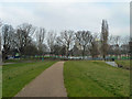
4
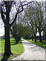
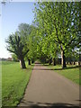
Sutcliffe Park
A path in the aforementioned park, lined with trees.
Image: © Stephen Richards
Taken: 1 Apr 2012
0.06 miles
5
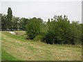
The Quaggy River flood defence scheme, Sutcliffe Park (2)
Image: © Mike Quinn
Taken: 2 Sep 2010
0.06 miles
6
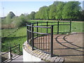
Viewing platform at Sutcliffe Park
A few years ago Sutcliffe Park was just another municipal stretch of grass. Then it was transformed by a flood defence scheme which brought the Quaggy River to the surface and created lakes, wetlands and boardwalks. This viewing platform enables people to look across the site. The road beyond the trees is Kidbrooke Park Road.
Image: © Marathon
Taken: 8 Apr 2011
0.06 miles
7
Sutcliffe Park
This path is on top of a bund around a landscaped flood area created for the Quaggy River, which formerly passed under the park in a long sewer. It returns underground for a short distance at the grey feature with black railings on the right.
Image: © Robin Webster
Taken: 4 Feb 2012
0.06 miles
8
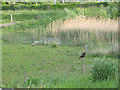
Birds in Sutcliffe Park
A crow perches on a fence post and some ducks enjoy the fringes of a reedy pond. Most of the park is in the neighbouring square - see Image
Image: © Stephen Craven
Taken: 9 May 2009
0.07 miles
9
Avenue of trees in Sutcliffe Park
Although Sutcliffe Park has been completely relandscaped as part of the Quaggy River flood defence scheme, some of the original features remain like this avenue of trees along the western side, parallel to Kidbrooke Park Road.
Image: © Marathon
Taken: 8 Apr 2011
0.07 miles
10
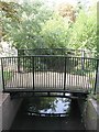
Footbridge over the Quaggy River west of Kidbrooke Park Road (A2213), SE3
Image: © Mike Quinn
Taken: 2 Sep 2010
0.08 miles