IMAGES TAKEN NEAR TO
Manorbrook, LONDON, SE3 9AW
Introduction
This page details the photographs taken nearby to Manorbrook, SE3 9AW by members of the Geograph project.
The Geograph project started in 2005 with the aim of publishing, organising and preserving representative images for every square kilometre of Great Britain, Ireland and the Isle of Man.

There are currently over 7.5m images from over14,400 individuals and you can help contribute to the project by visiting https://www.geograph.org.uk
Image Map
Images are licensed for reuse under creativecommons.org/licenses/by-sa/2.0
Notes
- Clicking on the map will re-center to the selected point.
- The higher the marker number, the further away the image location is from the centre of the postcode.
Image Listing (79 Images Found)
Images are licensed for reuse under creativecommons.org/licenses/by-sa/2.0
Image
Details
Distance
1
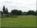
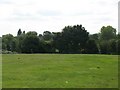
Former recreation ground south of Manor Way, SE3 (5)
A drain that feeds into Image runs in the trees at the far side of the grounds.
Image: © Mike Quinn
Taken: 2 Sep 2010
0.06 miles
2
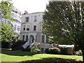
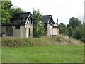
102 Manorbrook,
A Grade II listed building on Manor Way near Manorbrook.
Within the private Blackheath Cator Estate.
See http://www.britishlistedbuildings.co.uk/en-200449-102-eltham for more details about the building.
Image: © David Anstiss
Taken: 11 Sep 2011
0.06 miles
4
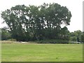
Former recreation ground south of Manor Way, SE3 (4)
A drain that feeds into Image runs in the trees at the far side of the grounds.
Image: © Mike Quinn
Taken: 2 Sep 2010
0.11 miles
5
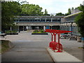
Thomas Tallis Secondary School, Kidbrooke Park Road
Built in the 1970s the fabric of the school is falling apart and will be replaced with a new building within the next decade. Very much a multi-ethnic inner London school, it is also extremely popular with parents over quite a radius and achieves excellent academic results
Image: © David Hatch
Taken: 18 Jun 2005
0.11 miles
6
Former sports pavilion, south of Manor Way, SE3
Image: © Mike Quinn
Taken: 2 Sep 2010
0.12 miles
7
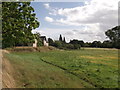
Disused Cricket Pavilion and Recreational Ground
This pavilion is beside Manor Park, within the private Blackheath Cator Estate.
It is now disused, as the field has been designated a flood control field. The field is beside the River Quaggy.
Image: © David Anstiss
Taken: 11 Sep 2011
0.13 miles
8
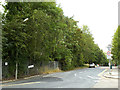
Moorhead Way, Kidbrooke
This used to be the perimeter road of the Ferrier Estate. At present (2014) it has become a dead end, blocked off round the northern end for construction of new housing in the new Kidbrooke Village. See Image for an earlier view of this stretch of road in the other direction.
Image: © Stephen Craven
Taken: 31 Jul 2014
0.13 miles
9
Former recreation ground south of Manor Way, SE3 (3)
A drain that feeds into Image runs in the trees at the far side of the grounds.
Image: © Mike Quinn
Taken: 2 Sep 2010
0.14 miles
10
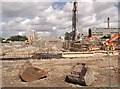
Kidbrooke Regeneration begins
New housing construction is started on Weigall Road.
In the background more blocks of the Ferrier Estate have yet to be demolished.
In the foreground, a piling machine and ringbeams (foundations) for the new buildings.
Image: © David Anstiss
Taken: 11 Sep 2011
0.15 miles