IMAGES TAKEN NEAR TO
Portmeadow Walk, LONDON, SE2 9UL
Introduction
This page details the photographs taken nearby to Portmeadow Walk, SE2 9UL by members of the Geograph project.
The Geograph project started in 2005 with the aim of publishing, organising and preserving representative images for every square kilometre of Great Britain, Ireland and the Isle of Man.

There are currently over 7.5m images from over14,400 individuals and you can help contribute to the project by visiting https://www.geograph.org.uk
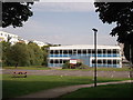
Image Map
Images are licensed for reuse under creativecommons.org/licenses/by-sa/2.0
Notes
- Clicking on the map will re-center to the selected point.
- The higher the marker number, the further away the image location is from the centre of the postcode.
Image Listing (82 Images Found)
Images are licensed for reuse under creativecommons.org/licenses/by-sa/2.0
Image
Details
Distance

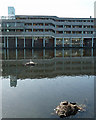
3
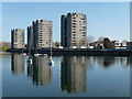
Thamesmead South Estate, Hartslock Drive
Four towers by South Mere, the largest of the lakes, Thamesmead's most striking features. This was the first part of Thamesmead, originally conceived by the Greater London Council as a new town with a population up to 100,000, dating from 1967-72. A mixture of towers with elevated walkways and maisonettes and flats beyond. Even though the population has yet to reach 50,000, today, the unrelenting expanses of tired concrete and brick are hard to take. Lest we judge the original planners too harshly, Pevsner remarks that, "Thamesmead today bears little resemblance to the ideal community visualized by its begetters".
Image: © Stephen Richards
Taken: 1 Apr 2012
0.05 miles
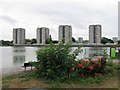
4
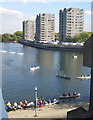
Thamesmead: South Mere
Epic open boat voyages in history, Shackleton, Bligh, etc., reenacted on South Mere in Thamesmead. I jest, sorry. Hartslock Drive flats viewed from Binsey Walk flats looking over South Mere with the local kids trying out their boating skills.
Image: © Nigel Cox
Taken: 4 Oct 2007
0.07 miles
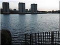
5
Thamesmead South Estate, Tavy Bridge
A tired block seen across South Mere, the largest of the lakes, Thamesmead's most striking features.
Meanwhile, oblivious to its unpromising and disheveled surroundings, nature was getting on with things - coots and swans had made island nests.
Image: © Stephen Richards
Taken: 1 Apr 2012
0.09 miles
7
Southmere Lake, Thamesmead
Southmere was the first artificial lake to be created in Thamesmead. This is the view from the Green Chain Walk looking across the lake on a wintry sunset. The tower blocks are part of the original 1970s Thamesmead and are in Hartslock Drive.
Image: © Marathon
Taken: 9 Feb 2016
0.10 miles
8
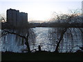
Wintry sunset over Southmere Lake
Southmere was the first artificial lake to be created in Thamesmead. This is the view from the Green Chain Walk looking across the lake to a wintry sunset. The tower blocks on the left are part of the original 1970s Thamesmead and are in Hartslock Drive.
Image: © Marathon
Taken: 9 Feb 2016
0.10 miles
9
Southlake Centre, Abbey Wood
As seen from Yanton Way.
Image: © David Anstiss
Taken: 21 Aug 2011
0.11 miles