IMAGES TAKEN NEAR TO
Manordene Road, LONDON, SE28 8EU
Introduction
This page details the photographs taken nearby to Manordene Road, SE28 8EU by members of the Geograph project.
The Geograph project started in 2005 with the aim of publishing, organising and preserving representative images for every square kilometre of Great Britain, Ireland and the Isle of Man.

There are currently over 7.5m images from over14,400 individuals and you can help contribute to the project by visiting https://www.geograph.org.uk
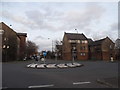
Image Map
Images are licensed for reuse under creativecommons.org/licenses/by-sa/2.0
Notes
- Clicking on the map will re-center to the selected point.
- The higher the marker number, the further away the image location is from the centre of the postcode.
Image Listing (53 Images Found)
Images are licensed for reuse under creativecommons.org/licenses/by-sa/2.0
Image
Details
Distance
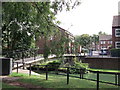
2
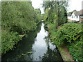
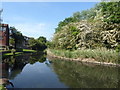
Waterway, Thamesmead
Part of an extensive drainage system, much of which has been incorporated into linear parks.
Image: © Robin Webster
Taken: 25 Jun 2011
0.09 miles
3
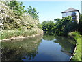
The lake at Crossway Park, Thamesmead
This is near the end of Watersmeet Way and is part of the Thamesmead Ecology Study Area. The island on the other side is not accessible. See https://londongardenstrust.org/inventory/gardens-online-record.php?ID=BEX012 for more information.
Image: © Marathon
Taken: 8 May 2020
0.09 miles
4
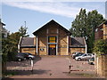
Manor Close Community Hall, Crossway
At the end of Manor Close, within the Crossway housing estate.
Image: © David Anstiss
Taken: 21 Aug 2011
0.10 miles
5
The lake at Crossway Park, Thamesmead
This is near the end of Watersmeet Way and is part of the Thamesmead Ecology Study Area. The island on the other side is not accessible. See https://londongardenstrust.org/inventory/gardens-online-record.php?ID=BEX012 for more information.
Image: © Marathon
Taken: 8 May 2020
0.11 miles
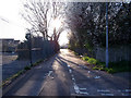
6
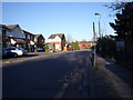
Copperfield Road
Looking east, with the fence of Castilion Primary School on the right and Voyagers Close off to the left.
Image: © Linda Craven
Taken: 9 Mar 2014
0.12 miles
7
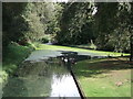
River junction in Crossways Housing Estate
As seen from Image
This river/drain flows through housing estate. It is popular with local wildlife, including ducks, swans and geese.
Image: © David Anstiss
Taken: 21 Aug 2011
0.12 miles
8
The Green Chain path passes under Crossway
This road bridge is one of several hereabouts with no proper footway provision over them and no direction to alternative routes for the stranger. It is evident from grass verge wear that this does not deter many, who have to walk on a narrow strip of deliberately uneven setts, with the danger of stumbling into the road. So the short-sighted designer has produced something that could kill.
Image: © Robin Webster
Taken: 25 Jun 2011
0.13 miles
9
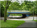
Footbridge on Green Chain Walk (2)
This footbridge leads between Kingfisher Close and Fieldfare Road (in the background), is used by the long distance path leading through the Crossway housing estate from the River Thames towards Southmere, Thamesmead.
It crosses over an algae filled drain/river within the estate
Image: © David Anstiss
Taken: 21 Aug 2011
0.13 miles
10
Footpath towards Manorway Green
This urban footpath leads from the western end of Copperfield Road to link to the north-south path along the Bexley/Greenwich border known as Manorway Green. To the left is the car park of Castilion Primary School.
Image: © Linda Craven
Taken: 9 Mar 2014
0.14 miles