IMAGES TAKEN NEAR TO
Miles Drive, LONDON, SE28 0NP
Introduction
This page details the photographs taken nearby to Miles Drive, SE28 0NP by members of the Geograph project.
The Geograph project started in 2005 with the aim of publishing, organising and preserving representative images for every square kilometre of Great Britain, Ireland and the Isle of Man.

There are currently over 7.5m images from over14,400 individuals and you can help contribute to the project by visiting https://www.geograph.org.uk
Image Map
Images are licensed for reuse under creativecommons.org/licenses/by-sa/2.0
Notes
- Clicking on the map will re-center to the selected point.
- The higher the marker number, the further away the image location is from the centre of the postcode.
Image Listing (86 Images Found)
Images are licensed for reuse under creativecommons.org/licenses/by-sa/2.0
Image
Details
Distance
1
View across the Thames from Gallions Hill
Image: © David Martin
Taken: 12 Apr 2016
0.03 miles
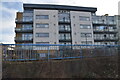
2
South end of Hill House, Woolwich
Maintenance on a not very old building.
Image: © Robin Webster
Taken: 25 Jun 2011
0.05 miles
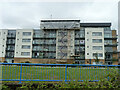
5
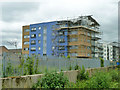
Scaffolding on Bridge House
This was for remedial work. According to the builders: "The scaffolding at Bridge House was erected following an issue relating to the penthouse properties, which required intrusive investigations". The scaffolding was up for so long the other tenants got rather fed up with it.
Image: © Robin Webster
Taken: 25 Jun 2011
0.06 miles
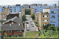
6
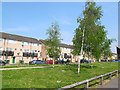
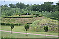
Miles Drive, Thamesmead
Low-rise housing with a wide, grassed central reservation.
Image: © Stephen Craven
Taken: 21 Apr 2014
0.09 miles
7
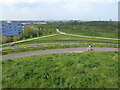
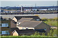
View from Gallions Hill
Gallions Hill is a sixty feet high landmark created from "recycled excavated material". A spiral path leads to the summit which provides widespread views up and down the Thames. To the south the views are only as far as the ridge between Shooters Hill, Plumstead Common, Bostall Heath and Lesnes Abbey Woods. This view looks over a newly-created park with the River Thames just beyond and the Barking Creek Barrier far right on the horizon.
Image: © Marathon
Taken: 11 Apr 2020
0.09 miles
8
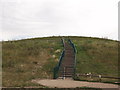
Steps up Gallions Hill
A path and steps lead from Bailey Close, to a path that swirls around the hill the top.
The hill is a twenty-metre-high landmark created from recycled excavated material.
Image: © David Anstiss
Taken: 21 Aug 2011
0.09 miles
9
Lesser hills from the top of Gallions Hill
Artificial mounds built on former marshland at Gallions Reach Park.
Image: © David Martin
Taken: 20 Jun 2021
0.09 miles
10
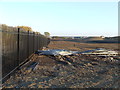
Earthworks, Thamesmead
Earth levelling work taking place in Thamesmead in 2011.
It appears that this site would have formed the approach to a planned Thames Gateway Bridge, a project which was abandoned in 2008. It's not clear what is now being done at this site.
Image: © Malc McDonald
Taken: 22 Oct 2011
0.09 miles