IMAGES TAKEN NEAR TO
Miles Close, LONDON, SE28 0NJ
Introduction
This page details the photographs taken nearby to Miles Close, SE28 0NJ by members of the Geograph project.
The Geograph project started in 2005 with the aim of publishing, organising and preserving representative images for every square kilometre of Great Britain, Ireland and the Isle of Man.

There are currently over 7.5m images from over14,400 individuals and you can help contribute to the project by visiting https://www.geograph.org.uk
Image Map
Images are licensed for reuse under creativecommons.org/licenses/by-sa/2.0
Notes
- Clicking on the map will re-center to the selected point.
- The higher the marker number, the further away the image location is from the centre of the postcode.
Image Listing (93 Images Found)
Images are licensed for reuse under creativecommons.org/licenses/by-sa/2.0
Image
Details
Distance
1
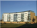
Flats on the River Thames
Several flats on the southern side of the river, I think they may be accommodation for students at the University of East London.
Image: © Ashley Dace
Taken: 30 Sep 2010
0.02 miles
2
Stepped tower blocks, Thamesmead
For more on Thamesmead visit http://www.hidden-london.com/thamesmead.html
Image: © Jim Osley
Taken: 14 Feb 2011
0.04 miles
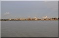
3
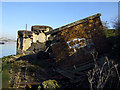
Gallions Reach WW2 defences
Two unusual WW2 defences overlooking Gallions Reach are slowly sliding down towards the river. Next to each other on the banks of the Thames are these variants. The pillbox behind is double-level with steps inside. It is covered in pitch. The pillbox in the foreground is a thin-walled brick variant, presumably a machine-gun emplacement. The area is littered with rubbish and debris including anti-tank concrete and rusting poles.
Both defences are in poor condition and badly vandalised. I had to walk a long way to find them and clamber down a very slippery river-bank to investigate these. Both appear to be unlisted by 'Defence of Britain'. If you have any more information about them, please email me. I have visited many pillboxes and never seen ones like this.
Image: © Julieanne Savage
Taken: 10 Feb 2008
0.04 miles
4
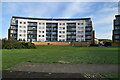
Apartments by the river, Thamesmead
A new apartment block in Thamesmead, South East London. These apartments have a view out over the River Thames.
Thamesmead is a new town developed since the 1960s, on reclaimed marshland south of the Thames.
Image: © Malc McDonald
Taken: 22 Oct 2011
0.04 miles
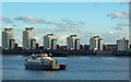
6
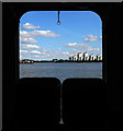
Thamesmead Estate from the Woolwich Ferry
Image: © Jim Osley
Taken: 22 Sep 2012
0.04 miles
7
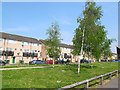
Miles Drive, Thamesmead
Low-rise housing with a wide, grassed central reservation.
Image: © Stephen Craven
Taken: 21 Apr 2014
0.05 miles
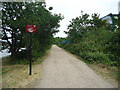
9
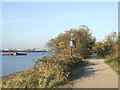
Thames Path at Gallions Reach
This section of the Thames Path, at Gallions Reach, is a shared path for pedestrians and cyclists. It forms part of Sustrans' National Cycle Network Route 1, which links Dover with Shetland generally following the east coast of England and Scotland.
Image: © Malc McDonald
Taken: 22 Oct 2011
0.05 miles