IMAGES TAKEN NEAR TO
Martins Walk, LONDON, SE28 0LE
Introduction
This page details the photographs taken nearby to Martins Walk, SE28 0LE by members of the Geograph project.
The Geograph project started in 2005 with the aim of publishing, organising and preserving representative images for every square kilometre of Great Britain, Ireland and the Isle of Man.

There are currently over 7.5m images from over14,400 individuals and you can help contribute to the project by visiting https://www.geograph.org.uk
Image Map
Images are licensed for reuse under creativecommons.org/licenses/by-sa/2.0
Notes
- Clicking on the map will re-center to the selected point.
- The higher the marker number, the further away the image location is from the centre of the postcode.
Image Listing (109 Images Found)
Images are licensed for reuse under creativecommons.org/licenses/by-sa/2.0
Image
Details
Distance
1
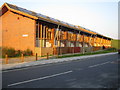
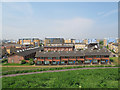
Thamesmead Ecopark: Tor Grove Block A
This is one of four blocks of sustainable social housing built for the Gallions Housing Association. The houses have, amongst other features, timber frames, advanced insulation and double glazing, condensing boilers, solar water heating through panels in the roofs, and waste separation units to encourage recycling, as well as sunspaces in their south-facing elevations. The houses in Block A here are two bedroom units. The Ecopark website is here http://www.gallionsecopark.co.uk/home.htm (This image was taken at sunset and the colour has not been enhanced).
Image: © Nigel Cox
Taken: 26 Mar 2007
0.01 miles
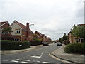
2
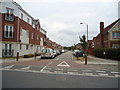
Martin Street, Thamesmead, London SE28
Image: © Stacey Harris
Taken: 5 Jun 2011
0.03 miles
4
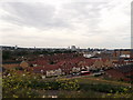
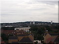
View over Gallions Reach Urban Village
Seen from Gallions Hill.
Looking over the new estate built on the former Royal Arsenal, Woolwich Ordnance factory site.
The River Thames is on the right.
Image: © David Anstiss
Taken: 21 Aug 2011
0.06 miles
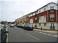
5
Tor Grove, Thamesmead
These new houses west of the Thamesmead Tor are designated an "eco park", or "passive houses" i.e. highly energy-efficient.
Image: © Stephen Craven
Taken: 21 Apr 2014
0.06 miles
7
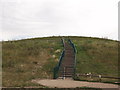
Steps up Gallions Hill
A path and steps lead from Bailey Close, to a path that swirls around the hill the top.
The hill is a twenty-metre-high landmark created from recycled excavated material.
Image: © David Anstiss
Taken: 21 Aug 2011
0.08 miles
8
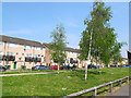
Miles Drive, Thamesmead
Low-rise housing with a wide, grassed central reservation.
Image: © Stephen Craven
Taken: 21 Apr 2014
0.08 miles
9
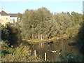
Geese on the canal, Thamesmead
Geese on a canal in Thamesmead, South East London.
Image: © Malc McDonald
Taken: 22 Oct 2011
0.08 miles
10
View towards Plumstead
As seen from Gallions Hill.
Looking over the Gallions Reach Urban Village (ecopark of houses).
The pale block in the background is Image
Further back is trees of Plumstead Common.
Image: © David Anstiss
Taken: 21 Aug 2011
0.09 miles