IMAGES TAKEN NEAR TO
Delisle Road, LONDON, SE28 0JD
Introduction
This page details the photographs taken nearby to Delisle Road, SE28 0JD by members of the Geograph project.
The Geograph project started in 2005 with the aim of publishing, organising and preserving representative images for every square kilometre of Great Britain, Ireland and the Isle of Man.

There are currently over 7.5m images from over14,400 individuals and you can help contribute to the project by visiting https://www.geograph.org.uk
Image Map
Images are licensed for reuse under creativecommons.org/licenses/by-sa/2.0
Notes
- Clicking on the map will re-center to the selected point.
- The higher the marker number, the further away the image location is from the centre of the postcode.
Image Listing (111 Images Found)
Images are licensed for reuse under creativecommons.org/licenses/by-sa/2.0
Image
Details
Distance
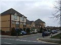
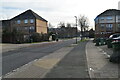
1
Martin Street, Thamesmead, London SE28
Image: © Stacey Harris
Taken: 5 Jun 2011
0.04 miles
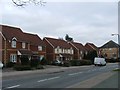
3
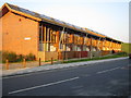
Thamesmead Ecopark: Tor Grove Block A
This is one of four blocks of sustainable social housing built for the Gallions Housing Association. The houses have, amongst other features, timber frames, advanced insulation and double glazing, condensing boilers, solar water heating through panels in the roofs, and waste separation units to encourage recycling, as well as sunspaces in their south-facing elevations. The houses in Block A here are two bedroom units. The Ecopark website is here http://www.gallionsecopark.co.uk/home.htm (This image was taken at sunset and the colour has not been enhanced).
Image: © Nigel Cox
Taken: 26 Mar 2007
0.05 miles
4
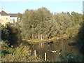
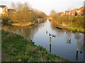
Geese on the canal, Thamesmead
Geese on a canal in Thamesmead, South East London.
Image: © Malc McDonald
Taken: 22 Oct 2011
0.05 miles
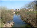
8
Thamesmead: Gallions Canal
Large parts of Thamesmead are on land originally contaminated by the activities of the former Woolwich Royal Arsenal. The land was first recovered by the GLC for residential use in the 1960s. As part of this redevelopment a system of canals and lakes were built in order to store and manage surface water run-off prior to its discharge into the River Thames. As part of the current development Tilfen Land Limited have retained and rebuilt sections of the old system, again to manage surface water run-off, including the provision of flood storage areas, but also to provide an ecology corridor and a public amenity through the residential areas. There is a .pdf file describing the scheme on Tilfen's website here http://www.tilfenland.co.uk/pdf/reshapingenvironments.pdf
This image was taken from the east side of Delisle Road with New Acres Road on the right. It is difficult to categorize the photo on the Geograph site in the sense that it is not an old navigable canal, nor a river, but an artificial drainage cut. "Drain" in the sense of a fenland drain therefore seems most suitable.
Image: © Nigel Cox
Taken: 26 Mar 2007
0.06 miles
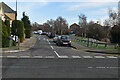
9
Canal at Thamesmead West
Thamesmead West was built from the 1990s onwards, and is a significant distance from the original development of Thamesmead from the late 1960s onwards. The landscaped canals here come from the time that this was part of Plumstead Marshes.
Image: © Marathon
Taken: 20 Mar 2015
0.07 miles