IMAGES TAKEN NEAR TO
Camelot Close, LONDON, SE28 0ES
Introduction
This page details the photographs taken nearby to Camelot Close, SE28 0ES by members of the Geograph project.
The Geograph project started in 2005 with the aim of publishing, organising and preserving representative images for every square kilometre of Great Britain, Ireland and the Isle of Man.

There are currently over 7.5m images from over14,400 individuals and you can help contribute to the project by visiting https://www.geograph.org.uk
Image Map
Images are licensed for reuse under creativecommons.org/licenses/by-sa/2.0
Notes
- Clicking on the map will re-center to the selected point.
- The higher the marker number, the further away the image location is from the centre of the postcode.
Image Listing (50 Images Found)
Images are licensed for reuse under creativecommons.org/licenses/by-sa/2.0
Image
Details
Distance
1
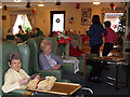
Christmas Day in a nursing home
Noon on Christmas Day and the residents of Gallions View Image are waiting for their Christmas lunch.
Image: © Stephen Craven
Taken: 25 Dec 2008
0.03 miles
2
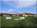
Gallions View
A BUPA nursing home for people with dementia and other care needs.
Image: © Stephen Craven
Taken: 18 Mar 2007
0.05 miles
3
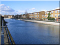
Pilkington Canal, Thamesmead
Only the first few hundred metres remain at the Thames end of the Pilkington Canal, and its connection to the river has been severed by recent development. It remains as a water feature in the Thamesmead housing development.
Image: © Stephen Craven
Taken: 18 Mar 2007
0.08 miles
4
Broadwater, Thamesmead
According to the Trust Thamesmead website, Broadwater Dock was originally part of the Ordnance Canal and Lock which was built by Napoleonic prisoners of war so that barges could load and unload the munitions alongside the factory buildings and not go through populated areas: http://www.trust-thamesmead.co.uk/
The dock is now drained, but a man died here in 2007 while saving the life of a boy who was drowning.
Image: © Malc McDonald
Taken: 22 Oct 2011
0.10 miles
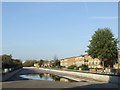
5
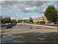
The Pilkington Canal, drained (1)
The canal was drained for maintenance for a few weeks in late 2009, revealing its concrete invert (bottom). The pools seen here are merely rainwater collecting in shallow depressions in the concrete. The depth, about 2m below the waterline, was less than I had imagined when previously seeing it full Image
Image: © Stephen Craven
Taken: 4 Oct 2009
0.11 miles
6
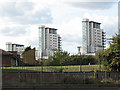
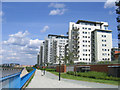
Towers on Erebus Drive, Thamesmead
This view shows three of seven apartment blocks of varying height on Erebus Drive, built circa 2005. The two tallest are called Sark Tower and Tideslea Tower (I am not sure which is which).
Image: © Stephen Craven
Taken: 4 Oct 2009
0.13 miles
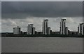
8
Tower blocks, Woolwich
The two tallest of a row of blocks of graduated height.
Image: © Robin Webster
Taken: 5 Mar 2011
0.13 miles
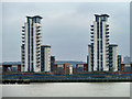
9
apartment blocks, Royal Arsenal site
some of the many apartment blocks that have been built in recent years on the old Royal Arsenal site at Woolwich.
Image: © Stephen Craven
Taken: 8 Jul 2006
0.13 miles
10
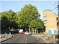
Whinchat Road, Thamesmead
Whinchat Road in West Thamesmead.
Image: © Malc McDonald
Taken: 22 Oct 2011
0.13 miles