IMAGES TAKEN NEAR TO
Dunkirk Street, LONDON, SE27 9JQ
Introduction
This page details the photographs taken nearby to Dunkirk Street, SE27 9JQ by members of the Geograph project.
The Geograph project started in 2005 with the aim of publishing, organising and preserving representative images for every square kilometre of Great Britain, Ireland and the Isle of Man.

There are currently over 7.5m images from over14,400 individuals and you can help contribute to the project by visiting https://www.geograph.org.uk
Image Map (Loading...)


Getting Data...Please wait
Leaflet Map data © OpenStreetMap
Images are licensed for reuse under creativecommons.org/licenses/by-sa/2.0
Notes
- Clicking on the map will re-center to the selected point.
- The higher the marker number, the further away the image location is from the centre of the postcode.
Image Listing (250 Images Found)
Images are licensed for reuse under creativecommons.org/licenses/by-sa/2.0
Image
Details
Distance
1
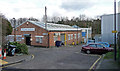
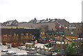
Waring Street
A short cul-de-sac off Norwood High Street with nothing much except a couple of industrial buildings - Waring House, and Zephyr House beyond.
Off to the left is an even shorter cul-de-sac, Dunkirk Street, which has virtually nothing except three houses opposite Waring House. The map suggests it may originally have continued north until it met Pilgrim Hill before being curtailed by the site now occupied by builders' merchants, Travis Perkins.
Image: © Stephen Richards
Taken: 6 Feb 2013
0.01 miles
2
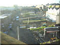
Industrial area near West Norwood Station, from the train
This area of builders' supply yards, light industry and mechanics' shops lies in a dip just to the east of (and parallel to) Norwood High Street, running south from the railway. The dip probably represents the old course of the Effra, one of London's lost rivers.
In the foreground, the beer garden of a pub on Norwood High Street
Image: © Christopher Hilton
Taken: 15 Oct 2011
0.02 miles

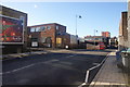
4
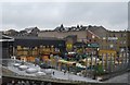
Travis Perkins lumberyard, off Northwood High St
Image: © N Chadwick
Taken: 8 May 2010
0.03 miles
5
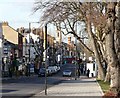
View down Elder Road
With a line of fine old gnarled trees growing in a variety of directions.
After the traffic lights the road becomes Norwood High Street.
In the distance are the towers of St Luke's church and the former fire station.
Image: © Stephen Richards
Taken: 30 Jan 2010
0.03 miles
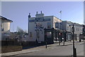
7
The Gipsy Queen Public House, West Norwood
Image: © Stacey Harris
Taken: 3 Jun 2009
0.04 miles
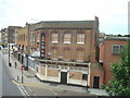
8
The Hope, West Norwood
Young's pub listed in the Good Beer Guide.
Image: © Bill Boaden
Taken: 1 Feb 2014
0.04 miles
9

Norwood High Street from West Norwood Station
Image: © Christopher Hilton
Taken: 15 Oct 2011
0.04 miles
10
Ernest Avenue, West Norwood
The road continues down to Norwood Garage on the left, which is the destination for many bus routes.
Image: © Bill Boaden
Taken: 1 Feb 2014
0.05 miles