IMAGES TAKEN NEAR TO
Canterbury Grove, LONDON, SE27 0NZ
Introduction
This page details the photographs taken nearby to Canterbury Grove, SE27 0NZ by members of the Geograph project.
The Geograph project started in 2005 with the aim of publishing, organising and preserving representative images for every square kilometre of Great Britain, Ireland and the Isle of Man.

There are currently over 7.5m images from over14,400 individuals and you can help contribute to the project by visiting https://www.geograph.org.uk
Image Map
Images are licensed for reuse under creativecommons.org/licenses/by-sa/2.0
Notes
- Clicking on the map will re-center to the selected point.
- The higher the marker number, the further away the image location is from the centre of the postcode.
Image Listing (39 Images Found)
Images are licensed for reuse under creativecommons.org/licenses/by-sa/2.0
Image
Details
Distance
1
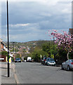
Canterbury Grove
The road descends towards Norwood Road, although it is interrupted by the railway which is crossed only by a footbridge.
The distant woods might be near Dulwich golf course.
Image: © Stephen Richards
Taken: 21 Apr 2012
0.08 miles
2
Royal Circus
Bath and Edinburgh may have better known examples, but their charms are obvious whereas West Norwood's requires an exercise of the imagination to fully appreciate its (potential) splendour.
Standing on high ground, it should have been the circular hub of a prestigious early Victorian development from which villa-lined roads would radiate, but it flopped and the surrounding houses are routine Victorian and early C20th fare. Behind the wooden fence is Tonge House, originally a "home for ladies", almshouses established by Bertha Portal, the present building also early C20th by the looks of it.
Image: © Stephen Richards
Taken: 17 Feb 2013
0.09 miles
3
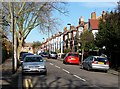
Thurlby Road (4)
Looking north along the long arm of the L-shaped Thurlby Road from near the junction with St Julian's Farm Road. This is pretty much the reverse of this view: Image
These houses were probably built in the second half of the C19th.
The development of West Norwood began with the breaking up of Lord Thurlow's estate after his death in 1806, but it accelerated greatly with the arrival of the Crystal Palace railway in 1856; between 1851 and 1901 the population of the district of St. Luke's, Norwood increased from around 4,000 to around 36,000.
Image: © Stephen Richards
Taken: Unknown
0.14 miles
4
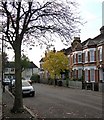
Thurlby Road (1)
Looking west along the short arm of the L-shaped Thurlby Road.
These houses were probably built in the second half of the C19th.
The development of West Norwood began with the breaking up of Lord Thurlow's estate after his death in 1806, but it accelerated greatly with the arrival of the Crystal Palace railway in 1856; between 1851 and 1901 the population of the district of St. Luke's, Norwood increased from around 4,000 to around 36,000.
The houses facing at the end are in Uffington Road, and look as if they were built between the wars.
Image: © Stephen Richards
Taken: Unknown
0.14 miles
5
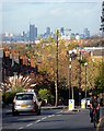
View down Knight's Hill (2)
A number of prominent buildings in central London are visible.
The tower under construction (above the car) is Strata, a block of flats at Elephant Castle (2007-10, by Hamilton's Architects).
Immediately to its left can be seen the dome of St Paul's Cathedral.
To its right can be seen the three Barbican towers - Cromwell, Shakespeare, and Lauderdale (1965-76, Chamberlin, Powell and Bon).
Pity the poor cyclist. He didn't even notice me standing in his way.
Image: © Stephen Richards
Taken: Unknown
0.17 miles
6
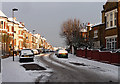
Snow in Thurlestone Road
Seen after a most unusual second December snowfall. These houses probably date from the second half of the C19th.
The development of West Norwood began with the breaking up of Lord Thurlow's estate after his death in 1806. Much of this initial phase has since been swept away by subsequent development which accelerated over the second half of the C19th and during the C20th, but there are pockets of houses surviving from the early days, mostly around Knight’s Hill, Norwood High Street/Elder Road and the area between them.
Image: © Stephen Richards
Taken: 20 Dec 2010
0.19 miles
7
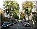
Uffington Road
Looking north along Uffington Road from the junction with St Julian's Farm Road.
Most of West Norwood was developed in Victorian and Edwardian times, but there is also a fair amount of housing from between the wars - the houses on the left look as if they were built during this period, while on the right are a couple of modern blocks.
Image: © Stephen Richards
Taken: Unknown
0.19 miles
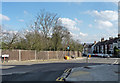
8
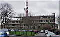
Development, Prioress Road
On a grey day it resembles offices of the Stasi, but this ugly duckling will transform itself into West Norwood's (swan-like?) leisure centre, housing a swimming pool, gym, dance studio, meeting rooms and GP surgery. It is being built on what was open space next to Norwood Hall, a nondescript, derelict post-war building (and itself a community hall) which has now been demolished.
Between Bloom Grove, from where this photo was taken, and the leisure centre runs the railway.
Swan phase: Image
Image: © Stephen Richards
Taken: 6 Feb 2013
0.19 miles
9
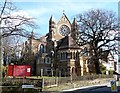
St Peter, Leigham Court Road
Built of polychromatic brick - rather fashionable at the time - in 1870 by R.W. Drew, with some later work by G.H. Fellowes Prynne in 1886-87. Grade II* listed.
Image: © Stephen Richards
Taken: Unknown
0.19 miles
10
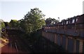
Railway Line to West Norwood
As seen from Image
This line leads from Tulse Hill towards West Norwood and onwards to Crystal Palace. On the right is Mount Villas (road) partially over the line.
In the background is a footbridge between two sections of Canterbury Grove.
Image: © David Anstiss
Taken: 2 Oct 2011
0.19 miles