IMAGES TAKEN NEAR TO
Nettlefold Place, LONDON, SE27 0JW
Introduction
This page details the photographs taken nearby to Nettlefold Place, SE27 0JW by members of the Geograph project.
The Geograph project started in 2005 with the aim of publishing, organising and preserving representative images for every square kilometre of Great Britain, Ireland and the Isle of Man.

There are currently over 7.5m images from over14,400 individuals and you can help contribute to the project by visiting https://www.geograph.org.uk
Image Map
Images are licensed for reuse under creativecommons.org/licenses/by-sa/2.0
Notes
- Clicking on the map will re-center to the selected point.
- The higher the marker number, the further away the image location is from the centre of the postcode.
Image Listing (222 Images Found)
Images are licensed for reuse under creativecommons.org/licenses/by-sa/2.0
Image
Details
Distance
1
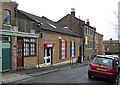
Nettlefold Place
A small loop off Knight's Hill currently comprising a mixture of residential, retail and light industrial uses. The building at the end appears to be in the process of conversion into offices. It would be interesting to know the original uses of these buildings.
The road is named after Frederick Nettlefold, local philanthropist, who lived at Norwood Grove, and industrialist whose company cornered the market in wood screws.
Image: © Stephen Richards
Taken: Unknown
0.01 miles
2
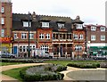
Former Library, Knight's Hill
Designed in 1887 by Sidney Smith, in a Flemish style, of red brick and terracotta with Ham Hillstone dressings. The seven stone busts on the first floor balcony depict Homer, Sir Walter Scott, Chaucer, Shakespeare, Milton, Dickens and Socrates. Grade II listed.
It was the first public library in Lambeth, but closed in 1968 after which it was superseded by a new library over the road. Since 2004 it has been a cafe and local community centre. It is within the West Norwood Conservation Area.
Image: © Stephen Richards
Taken: 9 Feb 2010
0.02 miles
3
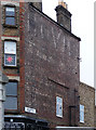
Ghost sign, Nettlefold Place
Beyond the first word, it's impossible to read the sign from this photograph. By increasing the colour saturation I was able to make out the following (the modern window obstructs two words):
"HOVIS
BREAD
THE WORLD'S BEST
THE HYGIENIC BAKERY
FAMOUS FOR
PURE DEVONSHIRE BREAD
CATERING & CONTRACTING [?]
IN ALL ITS BRANCHES [?]"
Image: © Stephen Richards
Taken: 5 Jan 2011
0.03 miles
4
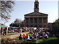
West Norwood Food Fair (2)
In the grounds of Image (in the background).
Part of the West Norwood Feast on Sunday 6th November, 10am - 4pm.
As seen from Knight's Hill (road).
See http://westnorwood.spacemakers.org.uk/ for more details about the fair.
Image: © David Anstiss
Taken: 2 Oct 2011
0.04 miles
5
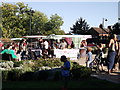
West Norwood Food Fair
In the grounds of Image churchyard.
Part of the West Norwood Feast on Sunday 6th November, 10am - 4pm.
As seen from Knight's Hill (road).
See http://westnorwood.spacemakers.org.uk/ for more details about the fair.
Image: © David Anstiss
Taken: 2 Oct 2011
0.04 miles
6
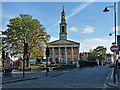
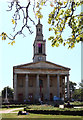
St Lukes Church, West Norwood
Building commenced in 1822 and the church was consecrated in 1825.
Standing prominently at the end of Norwood Road with Norwood High Street to the left and Knights Hill to the right.
Image: © Robin Drayton
Taken: 16 Sep 2012
0.04 miles
7
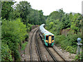
Train approaching West Norwood station
Unit 377 131 rounds the 30 limited curve.
Image: © Robin Webster
Taken: 23 Jul 2011
0.04 miles
8
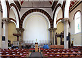
St Luke, Knights Hill, West Norwood - East end
Image: © John Salmon
Taken: 1 Aug 2013
0.05 miles
9
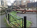
Storm damage at St Luke's Church
This tree, on the boundary of the churchyard with Knights Hill, only narrowly missed St Luke's Church. This was on 1st March and it would have been brought down by one of the three named storms of the previous month.
Image: © Marathon
Taken: 1 Mar 2022
0.05 miles