IMAGES TAKEN NEAR TO
Harpenden Road, LONDON, SE27 0AE
Introduction
This page details the photographs taken nearby to Harpenden Road, SE27 0AE by members of the Geograph project.
The Geograph project started in 2005 with the aim of publishing, organising and preserving representative images for every square kilometre of Great Britain, Ireland and the Isle of Man.

There are currently over 7.5m images from over14,400 individuals and you can help contribute to the project by visiting https://www.geograph.org.uk
Image Map
Images are licensed for reuse under creativecommons.org/licenses/by-sa/2.0
Notes
- Clicking on the map will re-center to the selected point.
- The higher the marker number, the further away the image location is from the centre of the postcode.
Image Listing (114 Images Found)
Images are licensed for reuse under creativecommons.org/licenses/by-sa/2.0
Image
Details
Distance
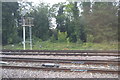
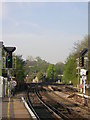
1
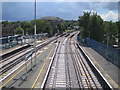
Tulse Hill railway station
Looking from the footbridge on the station over the freshly ballasted tracks towards the junction south of the station. A Southern train bound for West Norwood is just disappearing around the corner to the left, while the tracks to the right themselves split and go to Streatham and Streatham Hill stations respectively.
Image: © Nigel Cox
Taken: 18 Jul 2007
0.05 miles
2
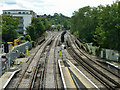
Railway junction at Tulse Hill
A close look at the points of the double junction ahead came as a bit of a shock. There are four possible settings for such a junction, three intrinsically safe and one unsafe. The safe settings are both tracks set left; both tracks set right; left set left with right set right. The settings as photographed are left set right, right set left. This produces a potential collision at the diamond crossing. Obviously signals and supposedly fail-safe train control devices would or should prevent this, but it is still disturbing.
Image: © Robin Webster
Taken: 23 Jul 2011
0.06 miles
5
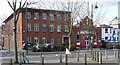
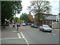
242-248 Norwood Road
Brick offices on the left, rather in the style of early-C20th telephone exchanges, and to its right the Salvation Army.
On the far right is No. 242, an early-C19th stuccoed house currently occupied by a company offering lifting platforms for hire, hence the interesting machinery outside. Grade II listed.
Image: © Stephen Richards
Taken: 9 Mar 2011
0.07 miles
6
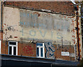
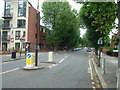
Ghost sign, Ullswater Road
It reads: "...DREYS / LUNCHEONS TEAS / WITH / HOVIS / Golden Brown(?)".
Image: © Stephen Richards
Taken: 9 Nov 2018
0.08 miles
7
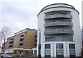
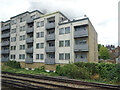
Ira Court, Tulse Hill
A distinctive development of 103 flats on Norwood Road, completed in 2008.
Image: © Derek Harper
Taken: 11 Mar 2011
0.09 miles
8
Tulse Hill station, looking south-westwards towards Streatham
Image: © Christopher Hilton
Taken: 19 Apr 2011
0.09 miles