IMAGES TAKEN NEAR TO
Hindsleys Place, LONDON, SE23 2NF
Introduction
This page details the photographs taken nearby to Hindsleys Place, SE23 2NF by members of the Geograph project.
The Geograph project started in 2005 with the aim of publishing, organising and preserving representative images for every square kilometre of Great Britain, Ireland and the Isle of Man.

There are currently over 7.5m images from over14,400 individuals and you can help contribute to the project by visiting https://www.geograph.org.uk
Image Map
Images are licensed for reuse under creativecommons.org/licenses/by-sa/2.0
Notes
- Clicking on the map will re-center to the selected point.
- The higher the marker number, the further away the image location is from the centre of the postcode.
Image Listing (124 Images Found)
Images are licensed for reuse under creativecommons.org/licenses/by-sa/2.0
Image
Details
Distance
1
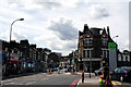
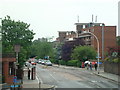
Approaching Forest Hill Station
Road names are not well defined here, but the South Circular (A205) goes off to the right on its sclerotic westward trek, while the pedestrian route to the station goes straight on.
Image: © Dr Neil Clifton
Taken: 23 Aug 2012
0.04 miles
3
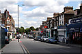
Forest Hill: view east from the station
I am not certain about road names here, but it seems the nearer part is part of Perry Vale, but further away (where it becomes also the South Circular Road), its local name is Waldram Park Road.
Image: © Dr Neil Clifton
Taken: 23 Aug 2012
0.04 miles
4
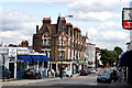
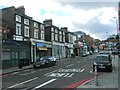
Forest Hill: view east from the station.
See Image Note the fine terrace on the left here.
Image: © Dr Neil Clifton
Taken: 23 Aug 2012
0.04 miles
6
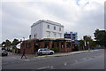
All Inn One, Forest Hill
Also known as The Foresters.
Image: © Bill Boaden
Taken: 11 Oct 2014
0.05 miles
8
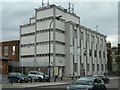
Forest Hill Telephone Exchange
On Waldram Park Road, SE23.
Image: © Danny P Robinson
Taken: 12 May 2007
0.05 miles
9
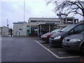
Forest Hill station entrance and car park
Image: © David Howard
Taken: 25 Jan 2009
0.05 miles
10
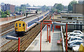
Forest Hill station with train, 1991
View southward, towards Norwood Junction, Croydon, Brighton etc.: ex-LB&SCR London Bridge - Norwwod Junction, East and West Croydon, Redhill, Brighton etc. A train of empty EMU stock is running along the Up Fast line ready for the evening rush-hour, headed by a 2-EPB set. This station was almost completely destroyed at 10.55 on 24/6/44 by a V-1 Flying Bomb and it was many years later that a modern replacement was built.
Image: © Ben Brooksbank
Taken: 5 Jul 1991
0.06 miles