IMAGES TAKEN NEAR TO
Highwood Close, LONDON, SE22 8NR
Introduction
This page details the photographs taken nearby to Highwood Close, SE22 8NR by members of the Geograph project.
The Geograph project started in 2005 with the aim of publishing, organising and preserving representative images for every square kilometre of Great Britain, Ireland and the Isle of Man.

There are currently over 7.5m images from over14,400 individuals and you can help contribute to the project by visiting https://www.geograph.org.uk
Image Map
Images are licensed for reuse under creativecommons.org/licenses/by-sa/2.0
Notes
- Clicking on the map will re-center to the selected point.
- The higher the marker number, the further away the image location is from the centre of the postcode.
Image Listing (190 Images Found)
Images are licensed for reuse under creativecommons.org/licenses/by-sa/2.0
Image
Details
Distance
1
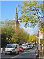
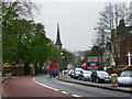
Lordship Lane, Dulwich
The road here forms part of the A205 South Circular Road; the spire of St Peter's Church is visible on the left.
Image: © Paul Harrop
Taken: 27 Oct 2017
0.03 miles
2
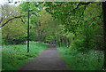
Cox's Walk
An Oak tree lined avenue cut in the 1740s.
Image: © N Chadwick
Taken: 9 May 2010
0.03 miles
3
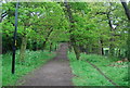
Cox's walk
An Oak tree lined avenue cut in 1740.
Image: © N Chadwick
Taken: 9 May 2010
0.04 miles
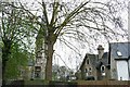
4
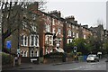
Houses on Lordship Lane
Most of these very large houses are subdivided into flats, of which the line of wheelie bins is a tell-tale sign.
Image: © David Martin
Taken: 27 Nov 2022
0.04 miles
6
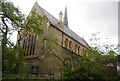
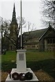
Former St Peter's Church, Dulwich
This grade II listed building was a C of E church then sold to be RC. It has now been sold on again to a pentecostal group.
Image: © N Chadwick
Taken: 9 May 2010
0.04 miles
7
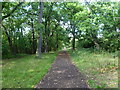
Cox's Walk
This oak-lined formal avenue is known as Cox's Walk and leads from the junction of Dulwich Common and Lordship Lane into Sydenham Hill Woods. It was cut soon after 1732 by Francis Cox to connect his establishment of the Green Man Tavern and Dulwich Wells with the more popular Sydenham Wells. In 1739, Francis Cox sank a well for his own family. The water was found to be possessed of purgative qualities, and was for some time used medicinally. Whilst the water was popular much custom was drawn to the adjoining tavern, and its proprietor flourished. The Green Chain Walk now follows Cox's Walk between Sydenham Hill Woods and Dulwich Park.
Image: © Marathon
Taken: 21 Sep 2011
0.05 miles
8
St Peter's Church, Dulwich Common, and derelict house
St Peter's is a former Church of England church, financed in part by the Horniman family who set up the nearby museum. After the Church of England declared it redundant it passed to a pentecostal group.
The derelict house is believed to be the only surviving 19th-century concrete house in England. In 1867 Charles Drake patented the use of iron panels for concrete shuttering and six years later his Patent Concrete Building Company erected his house.
For years it stood derelict, its architectural significance meaning that it could not be demolished. After this photograph was taken it was restored and converted to flats, the renovated building being reopened in 2013.
See https://en.wikipedia.org/wiki/Lordship_Lane,_Southwark for more information on the house and surrounding area.
Image: © Christopher Hilton
Taken: 9 Apr 2009
0.05 miles
9
St Peter's Church, Dulwich Common
A former C of E church, financed in part by the Horniman family who set up the nearby museum. The C of E no longer needed it and it is now owned by a pentecostal group; the church hall to the right seems to be used more than the (listed) church building.
Image: © Christopher Hilton
Taken: 9 Apr 2009
0.06 miles
10
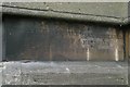
St Peter's Church, Dulwich Common: foundation stone
A former C of E church, financed in part by the Horniman family who set up the nearby museum. The C of E no longer needed it and it is now owned by a pentecostal group.
Image: © Christopher Hilton
Taken: 9 Apr 2009
0.06 miles