IMAGES TAKEN NEAR TO
Overhill Road, LONDON, SE22 0PY
Introduction
This page details the photographs taken nearby to Overhill Road, SE22 0PY by members of the Geograph project.
The Geograph project started in 2005 with the aim of publishing, organising and preserving representative images for every square kilometre of Great Britain, Ireland and the Isle of Man.

There are currently over 7.5m images from over14,400 individuals and you can help contribute to the project by visiting https://www.geograph.org.uk
Image Map
Images are licensed for reuse under creativecommons.org/licenses/by-sa/2.0
Notes
- Clicking on the map will re-center to the selected point.
- The higher the marker number, the further away the image location is from the centre of the postcode.
Image Listing (58 Images Found)
Images are licensed for reuse under creativecommons.org/licenses/by-sa/2.0
Image
Details
Distance
1
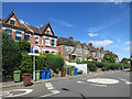
Underhill Road, Dulwich
Too small to see at this scale, but by the white fence is a footpath called Overhill Passage, so a bit of topography in the street names here.
Image: © Des Blenkinsopp
Taken: 9 Aug 2016
0.05 miles
2
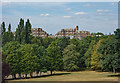
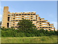
East Dulwich : Dawson's Heights
Built between 1964 and 1972 to design by architect Kate Macintosh of the London Borough of Southwark.
An account of the building of this housing estate may be found at this https://municipaldreams.wordpress.com/2014/11/25/dawsons-heights-east-dulwich-an-example-of-the-almost-lost-art-of-romantic-townscape/. View from Horniman Gardens.
Image: © Jim Osley
Taken: 4 Aug 2018
0.07 miles
3
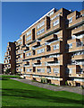
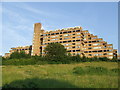
Dawson's Heights, Overhill Road (2)
A landmark building due to its elevated position, its craggy, stepped silhouette appearing as a man-made extension to the hill atop which it stands. Its 300 flats, each with its own balcony, are in two parallel ranges separated by a green space. In contrast to many public housing projects of the time - it was built in 1964-72 - it is clad in brown brick. Designed by Southwark Architect's Department. A listing application in 2012 by the Twentieth Century Society was rejected despite being supported by English Heritage.
Image: © Stephen Richards
Taken: 1 Nov 2014
0.08 miles
4
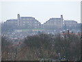
Dawson Heights, SE22
Dawson Heights, taken from Dog Kennel Hill.
Image: © Malc McDonald
Taken: 13 Mar 2010
0.09 miles
5
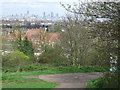
Dawson's Hill, SE22
A path on Dawson's Hill. Dawson's Hill has good views northwards towards Central London. In this image, the Swiss Re building (also known as "the gherkin") and Tower 42 (formerly the NatWest Tower) are both visible whilst "The Shard", which will be the tallest building in the European Union, is under construction. Just visible on the left of the image is the dome of St. Paul's Cathedral.
Image: © Malc McDonald
Taken: 3 Apr 2011
0.09 miles
6
Camberwell Old Cemetery
This is roughly the same area of the cemetery seen in Image, in different weather and season. The houses, hidden by foliage in that image, are on Underhill Road.
Image: © Derek Harper
Taken: 11 Mar 2011
0.09 miles
7
Dawson's Hill, East Dulwich
Path leading up Dawson's Hill, to the blocks of flats at the top.
Image: © Malc McDonald
Taken: 27 Jun 2010
0.09 miles
8
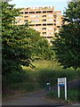
Dawson's Hill, East Dulwich
Dawson's Hill, with one of the twin blocks of Dawson Heights perched at the top.
Image: © Malc McDonald
Taken: 27 Jun 2010
0.10 miles
9
Dawson Heights, SE22
The twin blocks at Dawson Heights were built in 1972, and form a dramatic on the local skyline.
Image: © Malc McDonald
Taken: 27 Jun 2010
0.10 miles
10
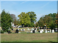
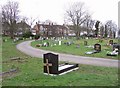
Camberwell Cemetery
The newer end, still in use judging by the digger and the space available.
Image: © Robin Webster
Taken: 1 Oct 2011
0.10 miles