IMAGES TAKEN NEAR TO
Carberry Road, LONDON, SE19 3RU
Introduction
This page details the photographs taken nearby to Carberry Road, SE19 3RU by members of the Geograph project.
The Geograph project started in 2005 with the aim of publishing, organising and preserving representative images for every square kilometre of Great Britain, Ireland and the Isle of Man.

There are currently over 7.5m images from over14,400 individuals and you can help contribute to the project by visiting https://www.geograph.org.uk
Image Map
Images are licensed for reuse under creativecommons.org/licenses/by-sa/2.0
Notes
- Clicking on the map will re-center to the selected point.
- The higher the marker number, the further away the image location is from the centre of the postcode.
Image Listing (454 Images Found)
Images are licensed for reuse under creativecommons.org/licenses/by-sa/2.0
Image
Details
Distance
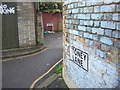
1
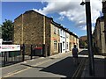
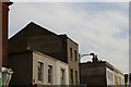
Carberry Road, Upper Norwood, southeast London
A glance at old-maps.org.uk shows that for decades after the later 19th century the Upper Norwood 'triangle' was a patchwork of lanes, short terraces of small houses, workshops and businesses. Carberry Road may retain something of that character, quite different from the scene in Image, which may date from the years either side of 1980.
Image: © Robin Stott
Taken: 2 Aug 2020
0.01 miles
2
Ovett Close meets Brunel Close, in the Norwood triangle
The centre of the Upper Norwood triangle used to be given over to light industry: joinery, engineering and so forth. Some works survive, but much of it now is made up of small housing estates, various cul-de-sac lanes into the triangle giving onto a network of pedestrian paths. Here Ovett Close coming in from the west meets Brunel Close coming in from the east and the two overlap; two no.24s face each other across the paving, to the despair of the local postmen.
Image: © Christopher Hilton
Taken: 30 Dec 2010
0.02 miles
3
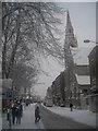
Westow Street in heavy snow
On the extreme right, a weatherboarded building creeps in which was the last surviving remnant of the original White Hart inn on the corner of Church Road and Westow Street. The White Hart itself was replaced in the later nineteenth century by a fanciful Gothic construction designed by Sextus Dyball, but a small portion of the earlier building remained, possibly a stable : see Image for the "new" building, where the last remnant of the old can be seen peeping, painted white, around the left side of the Gothic brickwork. The last portion of the original pub was knocked down in early 2015.
Image: © Christopher Hilton
Taken: 8 Jan 2009
0.02 miles
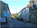
4
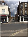
Carberry Road off Westow Street, Crystal Palace ?triangle?, south London
Looking across Westow Street from the corner of Haynes Lane.
Image: © Robin Stott
Taken: 28 May 2019
0.02 miles
5
Stoney Lane meets Telford Close, in the Norwood triangle
The centre of the Upper Norwood triangle used to be given over to light industry: joinery, engineering and so forth. Some works survive, but much of it now is made up of small housing estates, various cul-de-sac lanes into the triangle giving onto a network of pedestrian paths. Stoney Lane leads in from the south and here meets Telford Close coming in from the east.
Image: © Christopher Hilton
Taken: 30 Dec 2010
0.02 miles
7
Crystal Palace Rainbow Nursery, Carberry Road, Upper Norwood
Carberry Road is a quiet cul-de-sac in the villagey heart of the Crystal Palace 'triangle'. The ball-topped railings are believed to be locally made; pleasing examples may be come upon Image
Image: © Robin Stott
Taken: 2 Aug 2020
0.02 miles
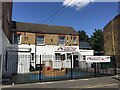
8
The Old Dairy, Carberry Road, Upper Norwood, London
Image: © Robin Stott
Taken: 2 Aug 2020
0.02 miles
9
Upper Norwood: "ghost-signs" on Westow Street
Image: © Christopher Hilton
Taken: 19 Feb 2008
0.03 miles
10
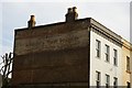
Upper Norwood: "ghost-sign" on Westow Street
"Drapery" is about all I can make out of this. However, a "blue plaque" sticker placed in 2017 in the window of the restaurant that then occupied the premises provided more detail, noting that from 1905 to 1979 this was the site of James Jackson's draper's shop. (See Image).
Image: © Christopher Hilton
Taken: 19 Feb 2008
0.03 miles