IMAGES TAKEN NEAR TO
Beulah Hill, LONDON, SE19 3LN
Introduction
This page details the photographs taken nearby to Beulah Hill, SE19 3LN by members of the Geograph project.
The Geograph project started in 2005 with the aim of publishing, organising and preserving representative images for every square kilometre of Great Britain, Ireland and the Isle of Man.

There are currently over 7.5m images from over14,400 individuals and you can help contribute to the project by visiting https://www.geograph.org.uk
Image Map
Images are licensed for reuse under creativecommons.org/licenses/by-sa/2.0
Notes
- Clicking on the map will re-center to the selected point.
- The higher the marker number, the further away the image location is from the centre of the postcode.
Image Listing (184 Images Found)
Images are licensed for reuse under creativecommons.org/licenses/by-sa/2.0
Image
Details
Distance
1
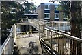
Ravensroost, Beulah Hill, Upper Norwood
This development appears to be flats (42) over parking. The address is 25-29 Beulah Hill.
Photo number 7650484.
Image: © Robin Stott
Taken: 3 Sep 2023
0.00 miles
2
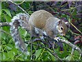
Grey Squirrel
In the woodlands of The Lawns, Spa Hill http://www.geograph.org.uk/photo/740188 .
Image: © Robin Drayton
Taken: 13 May 2017
0.04 miles
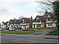
3
Houses, Beulah Hill, Upper Norwood
Set back from Beulah Hill, these distinctive half-timbered houses show their character with pride.
Photo number 7650520.
Image: © Robin Stott
Taken: 3 Sep 2023
0.04 miles
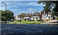
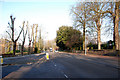
4
Beulah Hill
Mock Tudor houses set back from Beulah Hill which is a busy main road.
Image: © Robin Drayton
Taken: 24 Mar 2008
0.05 miles
5
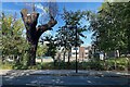
Lopped tree, Beulah Hill, Upper Norwood
The usual reason given for lopping a tree is that "It got too big", ignoring the reality that the poor tree wasn't allowed enough space when it was planted, or that the planter was unaware how big the tree would get. In the background is All Saints Primary School. It may be that there was nervousness, even fear, about branches, or the whole tree, falling. Another reason may be that it made a mess of the playground with falling leaves, flowers, twigs, fruits or seeds.
Photo number 7650446.
Image: © Robin Stott
Taken: 3 Sep 2023
0.06 miles
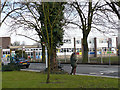
6
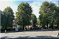
Junction of Beulah Hill and Grange Road
Photographed on opposite side of road to All Saints Church. All Saints School playing fields on right hand side of image behind trees
Image: © Chris L L
Taken: 29 Dec 2008
0.07 miles
7
The Lawns - the site of Beulah Spa
The name The Lawns does not give much indication of the history of this site but it was actually the location of the Beulah Spa. The properties of the mineral spring which was here had been known for many years and during a court case it was proved that the water contained more salts than the water at Cheltenham Spa. It could not rely though on income from people coming to take the waters so in 1831 it was opened as a place for entertainment. The gardens were laid out by Decimus Burton. Fine views were (and still are) to be had, and the entertainments included a maze, a circus and an orchestra. The water was bottled as Beulah Saline Water and sold for two shillings a gallon. The Spa’s popularity started to decline at the time that the Crystal Palace opened in 1854 and in 1858 the estate was put up for auction and much was subsequently developed. In 1939 ‘The Lawns Estate’ was conveyed to Croydon Corporation. The mast in the distance is the ITV mast at South Norwood, completed in 1955.
Image: © Marathon
Taken: 21 Oct 2011
0.07 miles
8
All Saints School
An artist painting All Saints Infant School, Upper Beulah Hill.
Image: © Robin Drayton
Taken: 24 Mar 2008
0.09 miles
9
Top of Grange Road, Upper Norwood
Despite the access off Grange Road the address of the flats is 13 Beulah Hill.
Photo number 7650382.
Image: © Robin Stott
Taken: 3 Sep 2023
0.10 miles
10
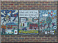
Mural at All Saints School
Near the entrance to All Saints Infant School, Upper Beulah Hill.
Image: © Robin Drayton
Taken: 24 Mar 2008
0.10 miles