1
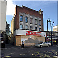
Former Burton's, now Plumbase, Crystal Palace
For an image of the foundation stone - laid, as interwar Burton's stores tended to be, by a member of the Burton family - see
Image
Image: © Christopher Hilton
Taken: 28 Jul 2014
0.02 miles
2
Boarded-up shop, Westow Hill, Upper Norwood, south London
The upper part of the facade is in Art Deco style. Could this have been a branch of Burton's?
Update, 5 June 2019
It was indeed a branch of Burton's: see Christopher Hilton's
Image and
Image
Image: © Robin Stott
Taken: 11 Oct 2018
0.02 miles
3
Brunel Close, Upper Norwood, south London
Bounded by busy Westow Hill, Westow Street and Church Road, this part of Upper Norwood is known as the Crystal Palace 'triangle'. At its heart is an intimate area of small businesses and 20th-century council-built two-storey houses threaded by a well-used network of footpaths. The view down the close is to St Aubyn's Road
Image
Image: © Robin Stott
Taken: 8 Oct 2018
0.02 miles
4
Tamnag Thai
Image: © N Chadwick
Taken: 11 May 2013
0.02 miles
5
Rear of Westow Hill, Upper Norwood, south London
The view from Brunel Close, one of the network of paths and closes at the residential heart of the Crystal Palace triangle. The bollarded access leads to some lock-up garages.
Image: © Robin Stott
Taken: 8 Oct 2018
0.03 miles
6
Upper Norwood: shops on Westow Hill
These small nineteenth-century cottages survive as shops, squeezed between taller late nineteenth-century structures with more pretensions to grandeur; the smaller ones may be survivors of the period before the Crystal Palace arrived in the 1860s and triggered large-scale development of the area.
Image: © Christopher Hilton
Taken: 29 Jul 2008
0.03 miles
7
Topiary training, Crystal Palace
A gardener in Ovett Close with a splendid hedge is using wire and careful pruning to train some topiary features: a duck in need of a bill, a vaguely disturbing rabbit and other works in progress.
Photo number 7606826.
Image: © Robin Stott
Taken: 25 May 2023
0.03 miles
8
Path between front gardens, Crystal Palace
Three heavily-trafficked, noisy streets intersect to form the Crystal Palace 'triangle' on top of the hill
Image Behind the shops, pubs and restaurants is this quiet, leafy, villagey interior of modest two-storey houses, small businesses, trees and gardens, all connected by footpaths and culs-de-sac. A bewildered visitor could not lose their way in a pleasanter spot.
Image: © Robin Stott
Taken: 2 Aug 2020
0.03 miles
9
St Aubyn's Road, Crystal Palace, south London
A residential road turning south off Westow Hill.
Image: © Robin Stott
Taken: 28 Aug 2017
0.03 miles
10
Metropolitan Water Board Fire Hydrant cover, Westow Hill, Upper Norwood
Near the top of Woodland Road, outside the hardware shop. The central text is FIRE HYDRANT in a rectangle. Above and below it HAM BAKER & CO LTD / MAKERS WESTMINSTER.SW. To the left of it MWB SD; to the right the number 4798.
Image: © Robin Stott
Taken: 8 Oct 2018
0.03 miles


