IMAGES TAKEN NEAR TO
St. Aubyns Road, LONDON, SE19 3AD
Introduction
This page details the photographs taken nearby to St. Aubyns Road, SE19 3AD by members of the Geograph project.
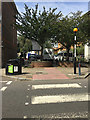
The Geograph project started in 2005 with the aim of publishing, organising and preserving representative images for every square kilometre of Great Britain, Ireland and the Isle of Man.

There are currently over 7.5m images from over14,400 individuals and you can help contribute to the project by visiting https://www.geograph.org.uk
Image Map
Images are licensed for reuse under creativecommons.org/licenses/by-sa/2.0
Notes
- Clicking on the map will re-center to the selected point.
- The higher the marker number, the further away the image location is from the centre of the postcode.
Image Listing (482 Images Found)
Images are licensed for reuse under creativecommons.org/licenses/by-sa/2.0
Image
Details
Distance
1
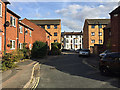
Brunel Close, Upper Norwood, south London
Bounded by busy Westow Hill, Westow Street and Church Road, this part of Upper Norwood is known as the Crystal Palace 'triangle'. At its heart is an intimate area of small businesses and 20th-century council-built two-storey houses threaded by a well-used network of footpaths. The view down the close is to St Aubyn's Road Image
Image: © Robin Stott
Taken: 8 Oct 2018
0.01 miles
2
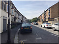
St Aubyn's Road, Crystal Palace, south London
A residential road turning south off Westow Hill.
Image: © Robin Stott
Taken: 28 Aug 2017
0.01 miles
3
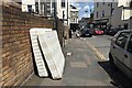
Parts of a bed, St Aubyn's Road, Upper Norwood, south London
Image: © Robin Stott
Taken: 2 Aug 2020
0.02 miles
4
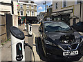
Electric car charging points, St Aubyn's Road, Crystal Palace, southeast London
This part of Crystal Palace (or Upper Norwood) is at the extreme northeast end of the London Borough of Croydon. Westow Hill is in the background.
Image: © Robin Stott
Taken: 2 Aug 2020
0.03 miles
5
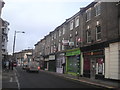
Upper Norwood: Church Road
Church Road, the eastern limb of the Upper Norwood triangle, is a less thriving retail artery than the other two sides of the triangle and specialises in quirkier or more specialised shops and businesses, some of them seemingly hanging on by their fingernails.
Image: © Christopher Hilton
Taken: 25 Jan 2011
0.03 miles

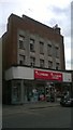
7
Boarded-up shop, Westow Hill, Upper Norwood, south London
The upper part of the facade is in Art Deco style. Could this have been a branch of Burton's?
Update, 5 June 2019
It was indeed a branch of Burton's: see Christopher Hilton's Image and Image
Image: © Robin Stott
Taken: 11 Oct 2018
0.03 miles
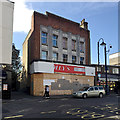
8
Former Burton's, now Plumbase, Crystal Palace
For an image of the foundation stone - laid, as interwar Burton's stores tended to be, by a member of the Burton family - see Image
Image: © Christopher Hilton
Taken: 28 Jul 2014
0.03 miles
10
Mollie Davies Court, Upper Norwood, southeast London
In the centre of the 'Crystal Palace Triangle' is a warren of closes and footpaths among two-storey housing. This is one way in on foot. The view is across Church Road. See the wear on the road paint – it's busy.
Image: © Robin Stott
Taken: 26 Aug 2017
0.04 miles