IMAGES TAKEN NEAR TO
St. Aubyns Road, LONDON, SE19 3AA
Introduction
This page details the photographs taken nearby to St. Aubyns Road, SE19 3AA by members of the Geograph project.
The Geograph project started in 2005 with the aim of publishing, organising and preserving representative images for every square kilometre of Great Britain, Ireland and the Isle of Man.

There are currently over 7.5m images from over14,400 individuals and you can help contribute to the project by visiting https://www.geograph.org.uk
Image Map
Images are licensed for reuse under creativecommons.org/licenses/by-sa/2.0
Notes
- Clicking on the map will re-center to the selected point.
- The higher the marker number, the further away the image location is from the centre of the postcode.
Image Listing (488 Images Found)
Images are licensed for reuse under creativecommons.org/licenses/by-sa/2.0
Image
Details
Distance
1
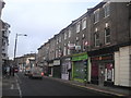
Upper Norwood: Church Road
Church Road, the eastern limb of the Upper Norwood triangle, is a less thriving retail artery than the other two sides of the triangle and specialises in quirkier or more specialised shops and businesses, some of them seemingly hanging on by their fingernails.
Image: © Christopher Hilton
Taken: 25 Jan 2011
0.01 miles
2
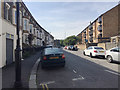
St Aubyn's Road, Crystal Palace, south London
A residential road turning south off Westow Hill.
Image: © Robin Stott
Taken: 28 Aug 2017
0.01 miles
3
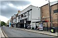
Everyman cinema, A212 Church Road, Crystal Palace
Last photographed in 2017 as 'Open Door' but a Rialto cinema in the past. Everyman is a chain of cinemas https://www.everymancinema.com/venues-list
Image: © Robin Stott
Taken: 16 May 2022
0.02 miles
4
Dereliction on A212 Church Road, Crystal Palace
Image: © Robin Stott
Taken: 16 May 2022
0.02 miles
5
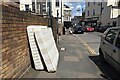
Parts of a bed, St Aubyn's Road, Upper Norwood, south London
Image: © Robin Stott
Taken: 2 Aug 2020
0.02 miles
6
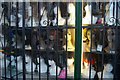
Upper Norwood: Kreative Lynk hair and beauty supplies, Church Road (detail)
Church Road, the eastern limb of the Upper Norwood triangle, is a less thriving retail artery than the other two sides of the triangle and specialises in quirkier or more specialised shops and businesses, some of them seemingly hanging on by their fingernails - though this one seems to have lasted well.
Image: © Christopher Hilton
Taken: 17 Jun 2008
0.03 miles
7
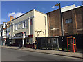
The Open Door and a bus stop, Church Road, Crystal Palace, south London
The Open Door is a stylish venue and event space, formerly The Rialto cinema which had opened in 1928. Some history is at http://www.theopendoor.org.uk
Image: © Robin Stott
Taken: 27 Aug 2017
0.03 miles

9
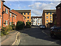
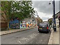
Brunel Close, Upper Norwood, south London
Bounded by busy Westow Hill, Westow Street and Church Road, this part of Upper Norwood is known as the Crystal Palace 'triangle'. At its heart is an intimate area of small businesses and 20th-century council-built two-storey houses threaded by a well-used network of footpaths. The view down the close is to St Aubyn's Road Image
Image: © Robin Stott
Taken: 8 Oct 2018
0.03 miles
10
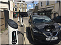
Electric car charging points, St Aubyn's Road, Crystal Palace, southeast London
This part of Crystal Palace (or Upper Norwood) is at the extreme northeast end of the London Borough of Croydon. Westow Hill is in the background.
Image: © Robin Stott
Taken: 2 Aug 2020
0.03 miles