IMAGES TAKEN NEAR TO
Hadlow Place, LONDON, SE19 2AX
Introduction
This page details the photographs taken nearby to Hadlow Place, SE19 2AX by members of the Geograph project.
The Geograph project started in 2005 with the aim of publishing, organising and preserving representative images for every square kilometre of Great Britain, Ireland and the Isle of Man.

There are currently over 7.5m images from over14,400 individuals and you can help contribute to the project by visiting https://www.geograph.org.uk
Image Map
Images are licensed for reuse under creativecommons.org/licenses/by-sa/2.0
Notes
- Clicking on the map will re-center to the selected point.
- The higher the marker number, the further away the image location is from the centre of the postcode.
Image Listing (432 Images Found)
Images are licensed for reuse under creativecommons.org/licenses/by-sa/2.0
Image
Details
Distance
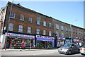
1
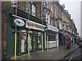
Anerley: Anerley Road
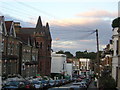
This unremarkable road, which is part of the A214, runs from an end-on junction with Anerley Hill at the 'Paxton Arms', for almost a mile southeast to its crossroads with the A213, where used to stand, but is no more, a large public house known as the 'Robin Hood', see Image This pub was a local point of reference, so that certain buses would display 'Anerley, Robin Hood' on their blinds. The origin of the district name Anerley is of some interest. Many, many years ago, before railways or even canals, a certain Scotsman built a farm here. He could see no other habitation from his farm, so he gave it the name 'Aneley' - Scottish for 'lonely'. Not so aneley now.
Image: © Dr Neil Clifton
Taken: 9 Mar 2010
0.01 miles
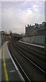
3
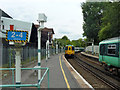
Down train leaving Crystal Palace
An eight car train with unit 455 803 trailing leaves platform 2.
Image: © Robin Webster
Taken: 23 Jul 2011
0.02 miles
4
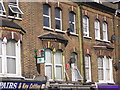
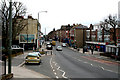
Flats above shops, Anerley Hill
I'm rather fond of the advertisement sticking out above the chemist's: "Full strength cough medicine in a pastille". It would be nice to think of that perhaps lasting as long as some of the tin advertising signs from the early 20th century.
Image: © Christopher Hilton
Taken: 30 Jul 2006
0.02 miles
5
Extended platforms, Crystal Palace station
The platforms at Crystal Palace and many other south London stations were extended during 2012-3 to enable the use of 10-carriage trains rather than the previous maximum of 8.
Image: © Christopher Hilton
Taken: 17 Mar 2014
0.02 miles
6
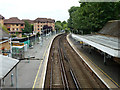
Platforms 1 and 2, Crystal Palace station
There are some distance from the other platforms off to the left.
Image: © Robin Webster
Taken: 23 Jul 2011
0.03 miles
8
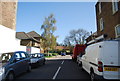
Waldegrave Road, SE19
In the middle distance on the left is the former Swedenborgian Church, now converted to flats. Note the old-fashioned telegraph pole radiating wires.
Image: © Christopher Hilton
Taken: 12 Oct 2010
0.04 miles
9
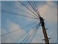
Telegraph pole, Waldegrave Road, SE19
Wires radiate from this pole, and a few like it, to every house in the street. It seems quite rare these days that such an arrangement should persist.
Image: © Christopher Hilton
Taken: 12 Oct 2010
0.04 miles