IMAGES TAKEN NEAR TO
Woodland Road, LONDON, SE19 1NS
Introduction
This page details the photographs taken nearby to Woodland Road, SE19 1NS by members of the Geograph project.
The Geograph project started in 2005 with the aim of publishing, organising and preserving representative images for every square kilometre of Great Britain, Ireland and the Isle of Man.

There are currently over 7.5m images from over14,400 individuals and you can help contribute to the project by visiting https://www.geograph.org.uk
Image Map
Images are licensed for reuse under creativecommons.org/licenses/by-sa/2.0
Notes
- Clicking on the map will re-center to the selected point.
- The higher the marker number, the further away the image location is from the centre of the postcode.
Image Listing (446 Images Found)
Images are licensed for reuse under creativecommons.org/licenses/by-sa/2.0
Image
Details
Distance
1
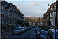
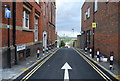
Woodland Road, Crystal Palace
A residential road offering views of the City of London.
Image: © Bill Boaden
Taken: 1 Feb 2014
0.01 miles

3
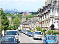
Woodland Road
Norwood street of Victorian terraced housing descending from Westow Hill. On the skyline is the City of London.
Image: © Colin Smith
Taken: 13 Jun 2009
0.02 miles
4
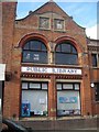
Upper Norwood Public Library
Upper Norwood straddles several boundaries: the two most significant local authorities in the area are Lambeth and Croydon (the library is in Lambeth, the photographer is standing in Croydon), although Southwark, Bromley and Lewisham also have a presence. As a result, the Library is jointly funded by the London Boroughs of Lambeth and Croydon, and their predecessors' arms can be seen on the gable end (see Image).
For the view through the archway creeping into the left of the shot, see Image
Image: © Christopher Hilton
Taken: 27 Jul 2008
0.02 miles
5
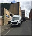
South and uphill on Beardell Street, Upper Norwood
A badly-dented van is parked by Smiths Coachworks. At the top of the slope Beardell Street meets Westow Hill.
Image: © Robin Stott
Taken: 27 May 2019
0.02 miles
6
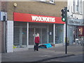
Upper Norwood Woolworth's, closed
Taken some 48 hours or so after the collapse of Woolworths led to the branch closing; a homeless person began sleeping in the door as soon as the shop closed, which was unusual for the Norwood triangle.
Image: © Christopher Hilton
Taken: 6 Jan 2009
0.03 miles
7
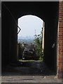
Upper Norwood: archway next to Library, giving view of the City
See Image for the Library, a bit of whose brickwork creeps in at the right of the shot.
Image: © Christopher Hilton
Taken: 27 Jul 2008
0.03 miles
9
Beardell Street, Crystal Palace
There is a stunning view across Westow Hill straight to the novelty office towers of the City of London. The public library, left, has stickers in its windows saying Upper Norwood Library Hub: for an explanation, see Image
Image: © Robin Stott
Taken: 18 Aug 2017
0.03 miles
10
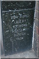
Foundation stone, former Burton's, Upper Norwood
On Westow Street, this has long ceased to be a branch of Burton's and is now a Plumbase, but the foundation stone survives. Its being laid by a member of the Burton family is typical of their interwar stores.
For an image of the building itself, see Image
Image: © Christopher Hilton
Taken: 14 Mar 2009
0.04 miles