IMAGES TAKEN NEAR TO
Vicars Oak Road, LONDON, SE19 1HE
Introduction
This page details the photographs taken nearby to Vicars Oak Road, SE19 1HE by members of the Geograph project.
The Geograph project started in 2005 with the aim of publishing, organising and preserving representative images for every square kilometre of Great Britain, Ireland and the Isle of Man.

There are currently over 7.5m images from over14,400 individuals and you can help contribute to the project by visiting https://www.geograph.org.uk
Image Map
Images are licensed for reuse under creativecommons.org/licenses/by-sa/2.0
Notes
- Clicking on the map will re-center to the selected point.
- The higher the marker number, the further away the image location is from the centre of the postcode.
Image Listing (367 Images Found)
Images are licensed for reuse under creativecommons.org/licenses/by-sa/2.0
Image
Details
Distance
1
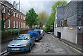
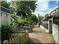
Central Hill Estate, SE19: Vicars Oak Road
Five London Boroughs meet on the hill at Upper Norwood, reflecting an earlier meeting of five parishes: the point at which the parish boundaries met, some few hundred yards east of this estate, was marked by a tree known as the Vicar's Oak, to which this street name nods.
Image: © Christopher Hilton
Taken: 22 Apr 2016
0.02 miles
2
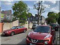
South and uphill on Vicar's Oak Road, Crystal Palace
Central Hill estate properties are on the right. Vicar's Oak Road leads up to Central Hill itself and the Crystal Palace 'triangle' on the hilltop.
Image: © Robin Stott
Taken: 19 May 2022
0.02 miles
3
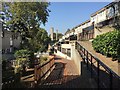
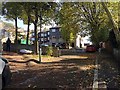
Part of the Plane Tree Walk section of the Central Hill Estate, Crystal Palace, London
The estate occupies a very steep slope on the northwest side of the Crystal Palace 'triangle'. It is managed by Lambeth Borough Council. Central Hill, A214, is the road west to Norwood.
Image: © Robin Stott
Taken: 10 Oct 2018
0.03 miles
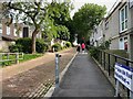
4
Central Hill estate ? north on Plane Tree Walk
Plane Tree Walk slopes gently down to Lunham Road. The ramp to the right takes people up to Vicar's Oak Road and on up to buses and shops. In the distance are the chimneys of the boiler house that might be called an incinerator. No longer used, it burnt waste to provide district heating.
Image: © Robin Stott
Taken: 19 May 2022
0.03 miles
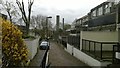
5
Uphill on Highland Road towards Vicars Oak Road, Upper Norwood, south London
The estate is in the London Borough of Lambeth. The road joins Central Hill.
Image: © Robin Stott
Taken: 10 Oct 2018
0.03 miles
6
South and uphill on Vicar's Oak Road, Crystal Palace
Image: © Robin Stott
Taken: 19 May 2022
0.04 miles
7
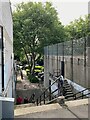
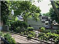
Central Hill estate ? steps by the disused boiler house
The steps connect Highland Road, behind the camera, with Plane Tree Walk.
Image: © Robin Stott
Taken: 19 May 2022
0.04 miles
8
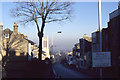
Gipsy Hill, SE19, January 2000
On the right, the "Welcome to the New Millennium in Lambeth" sign is one of the many markers at that time that we had just entered the year 2000.
On the left of the road, the tower of the former Christ Church (replaced by a modern building on the same site following an arson attack).
Image: © Christopher Hilton
Taken: 27 Jan 2000
0.04 miles
9
Central Hill estate ? Bankside Way houses from Vicar's Oak Road
The ramp descends to Plane Tree Walk.
Image: © Robin Stott
Taken: 19 May 2022
0.04 miles