IMAGES TAKEN NEAR TO
Woodhill, LONDON, SE18 5HL
Introduction
This page details the photographs taken nearby to Woodhill, SE18 5HL by members of the Geograph project.
The Geograph project started in 2005 with the aim of publishing, organising and preserving representative images for every square kilometre of Great Britain, Ireland and the Isle of Man.

There are currently over 7.5m images from over14,400 individuals and you can help contribute to the project by visiting https://www.geograph.org.uk
Image Map
Images are licensed for reuse under creativecommons.org/licenses/by-sa/2.0
Notes
- Clicking on the map will re-center to the selected point.
- The higher the marker number, the further away the image location is from the centre of the postcode.
Image Listing (135 Images Found)
Images are licensed for reuse under creativecommons.org/licenses/by-sa/2.0
Image
Details
Distance
1
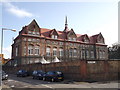
Woodhill School, Woolwich
This large Grade II listed school is on Woodhill (road).
See http://www.britishlistedbuildings.co.uk/en-396776-woodhill-school-woolwich for more details about the building.
Image: © David Anstiss
Taken: 11 Sep 2011
0.06 miles
2
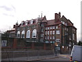
Woodhill School, Woolwich (2)
This large Grade II listed school is on Woodhill (road).
See Link for more details about the building
Image: © David Anstiss
Taken: 11 Sep 2011
0.07 miles
3
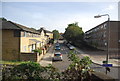
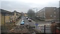
Woolwich: Pett Street / Woodhill subway
Taken from a little further away than Stephen's Image with Image on the right and the roof of Image just visible on the left, the pedestrian subway goes under the railway line about 500 metres west of Woolwich Dockyard railway station. The silver car visible through the subway is on Woolwich Church Street.
Image: © Nigel Cox
Taken: 5 Mar 2008
0.08 miles
5
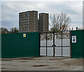
Demolition, Prospect Vale
The remnants of the 1960s Morris Walk Estate. One last tower is on its way out here, and a couple of others stand empty to the right of shot.
Greenwich council's Woolwich Estates regeneration project sees them demolishing two other estates so that they can build new ones.
Image: © Stephen Richards
Taken: 21 Nov 2020
0.09 miles
7
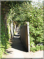
Urban footpath
An urban footpath or snicket running parallel to the railway line, between the junction of Maryon Road and Woodhill (the end shown here) and Prospect Vale.
Image: © Stephen Craven
Taken: 26 Aug 2007
0.11 miles
8
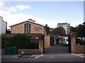
Woolwich Evangelical Church
On Woodhill (road).
Image: © David Anstiss
Taken: 11 Sep 2011
0.12 miles
9
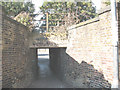
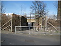
Pedestrian subway, Woodhill
This is where the road called Woodhill meets the North Kent railway line. A level crossing would have been obvious here, but there is only this pedestrian subway. According to a site visitor, it was shown on a large scale map in 1916. But it is not shown on modern street maps and is only known to locals.
Image: © Stephen Craven
Taken: 26 Aug 2007
0.12 miles