IMAGES TAKEN NEAR TO
Harrington Way, LONDON, SE18 5AQ
Introduction
This page details the photographs taken nearby to Harrington Way, SE18 5AQ by members of the Geograph project.
The Geograph project started in 2005 with the aim of publishing, organising and preserving representative images for every square kilometre of Great Britain, Ireland and the Isle of Man.

There are currently over 7.5m images from over14,400 individuals and you can help contribute to the project by visiting https://www.geograph.org.uk
Image Map (Loading...)


Getting Data...Please wait
Leaflet Map data © OpenStreetMap
Images are licensed for reuse under creativecommons.org/licenses/by-sa/2.0
Notes
- Clicking on the map will re-center to the selected point.
- The higher the marker number, the further away the image location is from the centre of the postcode.
Image Listing (166 Images Found)
Images are licensed for reuse under creativecommons.org/licenses/by-sa/2.0
Image
Details
Distance
1
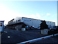
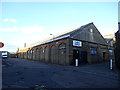
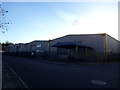
Trinity Wharf, buildings
These buildings on the Mellish Industrial estate in Charlton take their name from the nearby historic wharf of which only a small inlet remains Image A number of small businesses operate from here.
Image: © Stephen Craven
Taken: 16 Feb 2014
0.02 miles
2
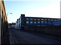
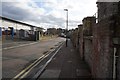
Industrial buildings on Warspite Road
High brick walls and 19th century factory buildings characterise this part of Charlton. The left hand side of the road in this view marks the western boundary of the Woolwich Dockyard at its fullest extent in the early 19th century.
Image: © Stephen Craven
Taken: 16 Feb 2014
0.03 miles
4
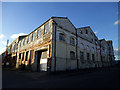
Factory on Warspite Road
This building is on the corner of Bowater Road which is a private road serving a number of industrial premises.
Image: © Stephen Craven
Taken: 16 Feb 2014
0.03 miles
6
Cable Depot, Warspite Road
This brick shed on the north-west corner of the former Woolwich Dockyard has an interesting history. It was designed by Edward George Rivers and built by Kirk and Randall in 1882–3 to store underwater cables for the General Post Office. It was in use for this purpose until the 1970s, then converted to light-industrial units, and retains the name Cable Depot. (source: http://www.english-heritage.org.uk/content/imported-docs/u-z/woolwich-chap2.pdf )
Image: © Stephen Craven
Taken: 16 Feb 2014
0.04 miles
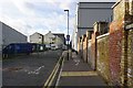
7
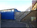
North end of Warspite Road
At one time this road - originally named Trinity Road - would have led directly onto the slipway called Trinity Wharf, but now terminates in the high concrete wall of the Thames flood defences, crossed by a flight of steps.
Image: © Stephen Craven
Taken: 16 Feb 2014
0.05 miles
8
Police patrol base, Warspite Road
For another view of this building see Image
Image: © Stephen Craven
Taken: 16 Feb 2014
0.06 miles
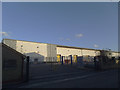
9
Newer industrial units on Warspite Road
Compare these with older industrial buildings nearby Image
Image: © Stephen Craven
Taken: 16 Feb 2014
0.06 miles
10
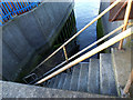
Steps to Trinity Wharf
Looking down from the top of the flood wall seen in Image, into the narrow inlet named on some maps as Trinity Wharf. The lower steps date from the time of rebuilding of the river wall in the 1830s, when the road now known as Warspite Road was called Trinity Street. The upper flight is modern, with the addition of a flood wall downstream of the Thames barrier in the 1980s. Seen at roughly mid-tide.
Image: © Stephen Craven
Taken: 16 Feb 2014
0.06 miles