IMAGES TAKEN NEAR TO
Berber Parade, LONDON, SE18 4GL
Introduction
This page details the photographs taken nearby to Berber Parade, SE18 4GL by members of the Geograph project.
The Geograph project started in 2005 with the aim of publishing, organising and preserving representative images for every square kilometre of Great Britain, Ireland and the Isle of Man.

There are currently over 7.5m images from over14,400 individuals and you can help contribute to the project by visiting https://www.geograph.org.uk
Image Map
Images are licensed for reuse under creativecommons.org/licenses/by-sa/2.0
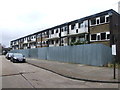
Notes
- Clicking on the map will re-center to the selected point.
- The higher the marker number, the further away the image location is from the centre of the postcode.
Image Listing (83 Images Found)
Images are licensed for reuse under creativecommons.org/licenses/by-sa/2.0
Image
Details
Distance
1
Gunyard Mews, Shooters Hill
Part of a private development of flats, soon to be extended south on the Shooters Hill estate which has just been demolished.
Image: © David Howard
Taken: 18 May 2014
0.03 miles
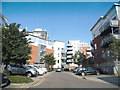
2
Modern Housing on Baker Road
On the junction with Master Gunner Place.
Image: © David Anstiss
Taken: 11 Sep 2011
0.03 miles
3
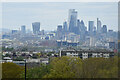
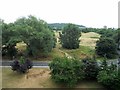
View over flats at Greenwich Heights to distant City skyline
The view from Shooters Hill towards the City of London. The apartment blocks in the foreground are part of the Greenwich Heights estate, just over a kilometre away.
Image: © David Martin
Taken: 9 May 2021
0.03 miles
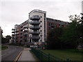
5
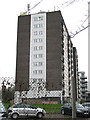
Greenwich Heights
The name of this block presumably derives from the fact that from its upper floors one could probably see Greenwich town. In fact it is located several kilometres away on the edge of Hornfair Park. The block was originally military accommodation (nearby Woolwich was home to the Royal Artillery until 2007). Its military origin may also explain the large number of aerials on top.
Image: © Stephen Craven
Taken: 27 Feb 2011
0.05 miles
6
Entrance To Woolwich Common
The view from the Greenwich Heights Apartment Block over Baker Road.
Image: © Ian Rob
Taken: 27 Jul 2013
0.05 miles
7
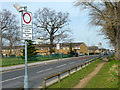
Baker Road, Woolwich
The near sign has been turned round, it applies to the road ahead, which principally serves Queen Elizabeth Hospital.
Image: © Robin Webster
Taken: 14 Mar 2012
0.05 miles
8
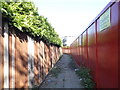
Path behind Tellson Avenue, Shooters Hill
The flats on the right are being demolished and the whole site is blocked by the fence.
Image: © David Howard
Taken: 18 May 2014
0.06 miles
9
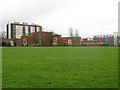
Housing on Master Gunner Place
The high-rise block in this view is Greenwich Heights. I have not found a name for the newer, lower rise blocks in the foreground. They overlook Hornfair Park (foreground). The name of the road they are on recalls the Heights' origin as military accommodation.
Image: © Stephen Craven
Taken: 27 Feb 2011
0.07 miles