IMAGES TAKEN NEAR TO
Gunyard Mews, LONDON, SE18 4GE
Introduction
This page details the photographs taken nearby to Gunyard Mews, SE18 4GE by members of the Geograph project.
The Geograph project started in 2005 with the aim of publishing, organising and preserving representative images for every square kilometre of Great Britain, Ireland and the Isle of Man.

There are currently over 7.5m images from over14,400 individuals and you can help contribute to the project by visiting https://www.geograph.org.uk
Image Map
Images are licensed for reuse under creativecommons.org/licenses/by-sa/2.0
Notes
- Clicking on the map will re-center to the selected point.
- The higher the marker number, the further away the image location is from the centre of the postcode.
Image Listing (89 Images Found)
Images are licensed for reuse under creativecommons.org/licenses/by-sa/2.0
Image
Details
Distance
1
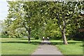
Avenue of trees on edge of Hornfair Park
Image: © David Martin
Taken: 9 May 2021
0.02 miles
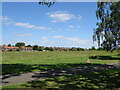
2
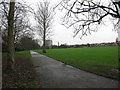
Hornfair Park: perimeter path
A macadam surfaced path running around the playing fields at the eastern end of the park.
Image: © Stephen Craven
Taken: 27 Feb 2011
0.02 miles
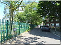
3
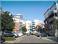
Gunyard Mews, Shooters Hill
Part of a private development of flats, soon to be extended south on the Shooters Hill estate which has just been demolished.
Image: © David Howard
Taken: 18 May 2014
0.04 miles
5
Stane Way
Looking north east beside Hornfair Park.
Image: © JThomas
Taken: 20 Jun 2022
0.05 miles
7
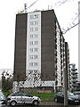
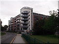
Greenwich Heights
The name of this block presumably derives from the fact that from its upper floors one could probably see Greenwich town. In fact it is located several kilometres away on the edge of Hornfair Park. The block was originally military accommodation (nearby Woolwich was home to the Royal Artillery until 2007). Its military origin may also explain the large number of aerials on top.
Image: © Stephen Craven
Taken: 27 Feb 2011
0.07 miles
8
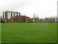
Hornfair Park
Recreational Park for leisure and sporting activities, including a large BMX track.
The Capital Ring and Green Chain Walk long distance paths both use the tarmac walkway seen heading towards the houses on Henry Road.
Image: © Chris Heaton
Taken: 24 Oct 2016
0.08 miles
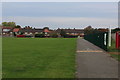
9
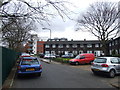
Housing on Master Gunner Place
The high-rise block in this view is Greenwich Heights. I have not found a name for the newer, lower rise blocks in the foreground. They overlook Hornfair Park (foreground). The name of the road they are on recalls the Heights' origin as military accommodation.
Image: © Stephen Craven
Taken: 27 Feb 2011
0.09 miles
10
Modern Housing on Baker Road
On the junction with Master Gunner Place.
Image: © David Anstiss
Taken: 11 Sep 2011
0.10 miles