IMAGES TAKEN NEAR TO
Shooters Hill, LONDON, SE18 3SA
Introduction
This page details the photographs taken nearby to Shooters Hill, SE18 3SA by members of the Geograph project.
The Geograph project started in 2005 with the aim of publishing, organising and preserving representative images for every square kilometre of Great Britain, Ireland and the Isle of Man.

There are currently over 7.5m images from over14,400 individuals and you can help contribute to the project by visiting https://www.geograph.org.uk
Image Map
Images are licensed for reuse under creativecommons.org/licenses/by-sa/2.0
Notes
- Clicking on the map will re-center to the selected point.
- The higher the marker number, the further away the image location is from the centre of the postcode.
Image Listing (136 Images Found)
Images are licensed for reuse under creativecommons.org/licenses/by-sa/2.0
Image
Details
Distance
1
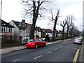
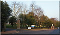
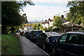
Shooters Hill
Looking uphill along the old Roman London to Canterbury road towards the landmark water tower at the summit.
This is the highest spot for a long way around which accounts for the number of masts up here.
Image: © Des Blenkinsopp
Taken: 8 Mar 2012
0.02 miles
2
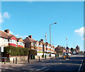
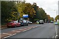
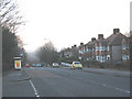
A207 Shooters Hill
By the Memorial Hospital (to the left). The bus stops are named after the hospital.
Image: © Robin Webster
Taken: 14 Mar 2012
0.02 miles
3
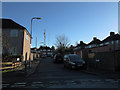
Hill End, Plumstead
A short dead-end street off Donaldson Road, running parallel to Shooters Hill. Two of the three transmission masts at the top of the hill, and the water tower, can be seen in the distance.
Image: © Stephen Craven
Taken: 11 Jan 2014
0.02 miles
4
Shooter's Hill, Woolwich, London, SE18
The entrance to the Memorial Hospital from the Old Dover Road (the A207). The car seen here is heading downhill towards central London.
Image: © David Hallam-Jones
Taken: 3 Apr 2013
0.02 miles
7
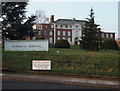
Shooter's Hill, Woolwich, London, SE18
Still functioning 88 years after it was built as a voluntary hospital in 1925, the Memorial Hospital is seen here from the opposite side of the A207. It now provides accommodation for in-patient and out-patient NHS psychiatric services and - elsewhere in the grounds - physiotherapy services.
Image: © David Hallam-Jones
Taken: 3 Apr 2013
0.04 miles
8
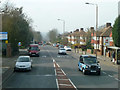
Shooters Hill
The A207 here was once the major route to eastern Kent. The City of London can be seen clearly ahead.
Image: © Bill Boaden
Taken: 11 Oct 2014
0.05 miles
9
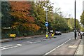
Shooters Hill, looking west
Shooters Hill is the highest point on the old A2 heading east from London. This view looks back from just below the summit towards central London about ten miles away (though the view on the days it was taken was too haze to make out the buildings of the City). The bus stop on the left serves the Memorial Hospital Image
Image: © Stephen Craven
Taken: 24 Jan 2009
0.05 miles