IMAGES TAKEN NEAR TO
Hinstock Road, LONDON, SE18 2TQ
Introduction
This page details the photographs taken nearby to Hinstock Road, SE18 2TQ by members of the Geograph project.
The Geograph project started in 2005 with the aim of publishing, organising and preserving representative images for every square kilometre of Great Britain, Ireland and the Isle of Man.

There are currently over 7.5m images from over14,400 individuals and you can help contribute to the project by visiting https://www.geograph.org.uk
Image Map (Loading...)


Getting Data...Please wait
Leaflet Map data © OpenStreetMap
Images are licensed for reuse under creativecommons.org/licenses/by-sa/2.0
Notes
- Clicking on the map will re-center to the selected point.
- The higher the marker number, the further away the image location is from the centre of the postcode.
Image Listing (48 Images Found)
Images are licensed for reuse under creativecommons.org/licenses/by-sa/2.0
Image
Details
Distance
1
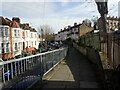
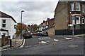
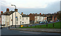
Ennis Road, Plumstead Common
In many ways the roads around Plumstead Common are very like the North of England, rather than London. Here Ennis Road is on the left and Upton Road on the right.
Image: © Marathon
Taken: 20 Feb 2021
0.05 miles
2
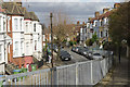
Ennis Road, Plumstead
Ennis Road curves away from Admaston Road on land that slopes down from Shrewsbury Park and the Shooters Hill area.
Image: © Stephen McKay
Taken: 20 Mar 2018
0.07 miles
3
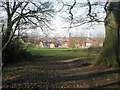
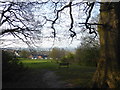
View from Shrewsbury Park
Shrewsbury Park on the slopes of Shooters Hill is an attractive, partly wooded park with fine views to the north. Here it is looking towards Rowton Road and the streets of Plumstead with the River Thames at Woolwich just visible in the distance.
Image: © Marathon
Taken: 8 Mar 2011
0.07 miles
4
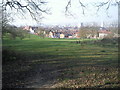
Shrewsbury Park view
Shrewsbury Park on the slopes of Shooters Hill is an attractive, partly wooded park with fine views to the north-west and north-east. Here it is looking towards Rowton Road and the streets of Victorian Plumstead.
Image: © Marathon
Taken: 8 Mar 2011
0.07 miles
6
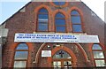
St Michael's Church, Plumstead
This is one of the more unusual denominations that I have come across. It is in Admaston Road, Plumstead Common.
Image: © Marathon
Taken: 9 Mar 2021
0.08 miles
7
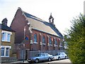
Cherubim and Seraphim church, Palmerston Crescent
Former Anglican church of St Alban which closed sometime before WW2. After the War it was used as a warehouse but since 1980 has been used as a church again.
Image: © Stephen Craven
Taken: 14 Jul 2005
0.09 miles
9
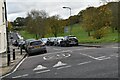
Rowton Road, Shrewsbury Park
From across Plum Lane. the frequent appearance of grit bins bears witness to the extremely steep roads on the descent from Shooters Hill.
Image: © Derek Harper
Taken: 4 Jan 2019
0.09 miles
10
View from Shrewsbury Park
This is as you enter the grassland between Rowton Road and the woodland of Shrewsbury Park. It looks north-westwards towards London, taking in Stratford and the Olympic Park, with Alexandra Palace on the horizon - see also https://www.geograph.org.uk/photo/6441029
Image: © Marathon
Taken: 9 Apr 2020
0.10 miles