IMAGES TAKEN NEAR TO
Landstead Road, LONDON, SE18 2LH
Introduction
This page details the photographs taken nearby to Landstead Road, SE18 2LH by members of the Geograph project.
The Geograph project started in 2005 with the aim of publishing, organising and preserving representative images for every square kilometre of Great Britain, Ireland and the Isle of Man.

There are currently over 7.5m images from over14,400 individuals and you can help contribute to the project by visiting https://www.geograph.org.uk
Image Map
Images are licensed for reuse under creativecommons.org/licenses/by-sa/2.0
Notes
- Clicking on the map will re-center to the selected point.
- The higher the marker number, the further away the image location is from the centre of the postcode.
Image Listing (26 Images Found)
Images are licensed for reuse under creativecommons.org/licenses/by-sa/2.0
Image
Details
Distance
1
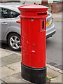
Plumstead: postbox № SE18 73, Flaxton Road
A very rare 'Type E' postbox, of which only a couple of dozen survive in use today. The posting slot is at one end of the oval rather than along a side as might be expected... that's because there is a (now disused) stamp vending machine on the other side.
See Image for detail of the stamp machine.
Image: © Chris Downer
Taken: 1 Apr 2018
0.10 miles
2
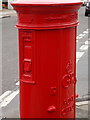
Plumstead: detail of a Type E postbox
This very rare oval postbox is one of only a couple of dozen 'Type E' postboxes which survive on the street. The posting slot is on the other end of the box, while this side has a (now disused) stamp vending machine, which we see here.
See Image for the front view of the box.
Image: © Chris Downer
Taken: 1 Apr 2018
0.10 miles
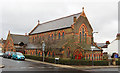
3
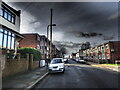
Alabama Street, Plumstead
Alabama Street has, like much of this part of Plumstead, Victorian houses on either side of the street except for a gap between Lucknow Street and Pegwell Street. On either side of Alabama Street there are terraces of modern houses.
The reason is that at 20.00 hours on 20th March 1941, a high explosive land mine came down here, killing a total of 27 people. Two gravestones to some of them can be seen at https://www.geograph.org.uk/photo/6466124 and https://www.geograph.org.uk/photo/6493852
Image: © Marathon
Taken: 15 Feb 2021
0.11 miles
4
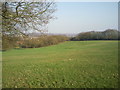
Shrewsbury Park
From the upper reaches of Shrewsbury Park, there are extensive views down to Plumstead Common and across the Thames. In this view, Bostall Woods are on the left horizon behind the tree, whilst to the right is looking towards Bexleyheath.
Image: © Marathon
Taken: 8 Mar 2011
0.19 miles

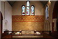
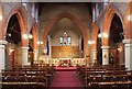

10
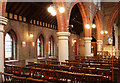
The Ascension, Plumstead - North arcade
Image: © John Salmon
Taken: 27 Nov 2012
0.20 miles