IMAGES TAKEN NEAR TO
Kings Highway, LONDON, SE18 2BH
Introduction
This page details the photographs taken nearby to Kings Highway, SE18 2BH by members of the Geograph project.
The Geograph project started in 2005 with the aim of publishing, organising and preserving representative images for every square kilometre of Great Britain, Ireland and the Isle of Man.

There are currently over 7.5m images from over14,400 individuals and you can help contribute to the project by visiting https://www.geograph.org.uk
Image Map (Loading...)


Getting Data...Please wait
Leaflet Map data © OpenStreetMap
Images are licensed for reuse under creativecommons.org/licenses/by-sa/2.0
Notes
- Clicking on the map will re-center to the selected point.
- The higher the marker number, the further away the image location is from the centre of the postcode.
Image Listing (178 Images Found)
Images are licensed for reuse under creativecommons.org/licenses/by-sa/2.0
Image
Details
Distance
1
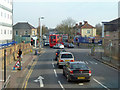
Junction on Wickham Lane, A209
96 and 422 buses squeeze past each other.
Image: © Robin Webster
Taken: 14 Mar 2012
0.04 miles
2
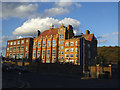
Former St Paul's school, Plumstead
Originally a Catholic secondary school, more recently an Academy. The Academy has now moved to a new site about 1.5km away Image and I am unsure what this old building is used for now. The high-stacked temporary buildings used for a while when the academy first expanded on this site Image have now gone.
Image: © Stephen Craven
Taken: 1 Nov 2014
0.05 miles
4
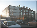
St Paul's school, Abbey Wood
A Roman Catholic secondary school.
Image: © Stephen Craven
Taken: 7 Dec 2008
0.06 miles
5
Steps down from Winns Common
Plumstead Common was purchased for the people in 1877. Before that, the parish council had grazing rights and free access, even though the land was owned by Queens College, Oxford. From 1871 the College had allowed the Army access and it was largely turned into a military training ground. This led to a storm of protest and a procession to the Common took place. Their leader was temporarily imprisoned and further protest took place until an Act of Parliament authorised purchase of the Common by the Metropolitan Board of Works.
The eastern part of Plumstead Common is known as Winns Common and this part of the Common is characterised by steep roads leading down towards lower Plumstead and also steep slopes to the east and south. These steps lead down to King's Highway.
Image: © Marathon
Taken: 11 Nov 2016
0.15 miles
6
Steps down from Winns Common
Plumstead Common was purchased for the people in 1877. Before that, the parish council had grazing rights and free access, even though the land was owned by Queens College, Oxford. From 1871 the College had allowed the Army access and it was largely turned into a military training ground. This led to a storm of protest and a procession to the Common took place. Their leader was temporarily imprisoned and further protest took place until an Act of Parliament authorised purchase of the Common by the Metropolitan Board of Works.
The eastern part of Plumstead Common is known as Winns Common and this part of the Common is characterised by steep roads leading down towards lower Plumstead and also steep slopes to the east and south. These steps lead down to King's Highway from the part of the Common called Bleak Hill.
Image: © Marathon
Taken: 11 Nov 2016
0.15 miles
7
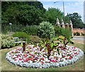
Flower bed near main entrance, Woolwich Old Cemetery
Woolwich Cemetery is in two parts, west and east, divided by Rockliffe Gardens. This is the Old Cemetery to the west, founded in 1856 by the Woolwich Burial Board. They laid out the 12-acre site which was formerly part of Plumstead Common. This is at the lowest part of the cemetery with the gate leading out to King's Highway beyond. The trees on the far side of King's Highway are on the slope of Winn's Common, which is the eastern part of Plumstead Common.
Image: © Marathon
Taken: 27 Jul 2013
0.15 miles
8
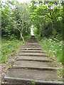
Path up on to Bleak Hill
These steep steps (108 of them) lead up through woodland from King's Highway to Winns Common which in turn is part of Plumstead Common.
Image: © Marathon
Taken: 30 Apr 2020
0.15 miles
9
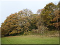
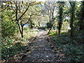
Bostall Woods on the last day of November
This was the last day of November and many leaves were still clinging on despite recent gales and freezing temperatures. Bostall Woods is largely on the side of a steep hill which rises up to a plateau of beech woods - see http://www.geograph.org.uk/photo/5592366 for example This is at the end of Waterdale Road at the foot of the slope.
Image: © Marathon
Taken: 30 Nov 2017
0.15 miles
10
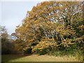
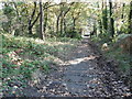
Bostall Woods at the end of November
This was the last day of November and many leaves were still clinging on despite recent gales and freezing temperatures. Bostall Woods is largely on the side of a steep hill which rises up to a plateau of beech woods - see http://www.geograph.org.uk/photo/5592366 for example This is at the end of Waterdale Road at the foot of the slope.
Image: © Marathon
Taken: 30 Nov 2017
0.15 miles