IMAGES TAKEN NEAR TO
Viewland Road, LONDON, SE18 1PE
Introduction
This page details the photographs taken nearby to Viewland Road, SE18 1PE by members of the Geograph project.
The Geograph project started in 2005 with the aim of publishing, organising and preserving representative images for every square kilometre of Great Britain, Ireland and the Isle of Man.

There are currently over 7.5m images from over14,400 individuals and you can help contribute to the project by visiting https://www.geograph.org.uk
Image Map
Images are licensed for reuse under creativecommons.org/licenses/by-sa/2.0
Notes
- Clicking on the map will re-center to the selected point.
- The higher the marker number, the further away the image location is from the centre of the postcode.
Image Listing (72 Images Found)
Images are licensed for reuse under creativecommons.org/licenses/by-sa/2.0
Image
Details
Distance
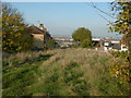
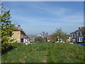
1
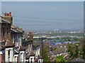
Viewland Road, Plumstead Common
Plumstead Common is as near as the North of England you can get in London. It has ravines, steep steps and houses built up hillsides. It also has excellent views across to the River Thames and to north-east London.
This view looks down Viewland Road. The Barking Creek Barrier is clearly visible right of centre, and Belmarsh Prison is in front of it.
Image: © Marathon
Taken: 15 Apr 2020
0.02 miles
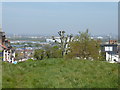
2
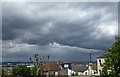
Storm clouds over Plumstead
This was a day of heavy showers and some bright sunshine. Despite appearances, there was no rain locally for much of the rest of the day although I would imagine it was fairly wet over north-east London which was the direction this photograph was taken. This was from the top of Viewland Road on Plumstead Common. The Barking Creek Barrier is on the far left of the picture.
Image: © Marathon
Taken: 1 May 2020
0.02 miles
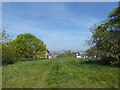
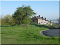
3
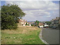
Viewland Road, Plumstead Common
The ridge on which Plumstead Common lies provides fine views northwards across the Thames. This part of Plumstead Common is actually known as Winns Common and all the roads leading down from here to lower Plumstead are very steep. The road ahead is appropriately called Viewland Road and to the right is Heath Villas, giving another clue about the history of the Common.
Image: © Marathon
Taken: 30 Aug 2010
0.02 miles
4
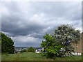
A stormy sky seen from Plumstead Common
This was a day of heavy showers and some bright sunshine. Despite appearances, there was no rain locally for much of the rest of the day although I would imagine it was fairly wet over north-east London which was the direction this photograph was taken. This was from the top of Viewland Road on Plumstead Common. The Barking Creek Barrier is on the far left of the view, just before the tree.
Image: © Marathon
Taken: 1 May 2020
0.03 miles
5
The top of Viewland Road from Winns Common
Plumstead Common was purchased for the people in 1877. Before that, the parish council had grazing rights and free access, even though the land was owned by Queens College, Oxford. From 1871 the College had allowed the Army access and it was largely turned into a military training ground. This led to a storm of protest and a procession to the Common took place. Their leader was temporarily imprisoned and further protest took place until an Act of Parliament authorised purchase of the Common by the Metropolitan Board of Works.
The eastern part of Plumstead Common is known as Winns Common and this part of the Common is characterised by steep roads leading down towards lower Plumstead and also steep slopes to the east and south. The road ahead is appropriately called Viewland Road.
Image: © Marathon
Taken: 11 Nov 2016
0.03 miles
6
Viewland Road from Plumstead Common
Plumstead Common is as near as the North of England you can get in London. It has ravines, steep steps and houses built up hillsides. It also has excellent views across to the River Thames and to north-east London.
This view looks down towards Viewland Road from Plumstead Common, which is here locally known as Winns Common. The Barking Creek Barrier is clearly visible on the left and Belmarsh Prison is straight in front of it.
Image: © Marathon
Taken: 15 Apr 2020
0.03 miles
7
Plumstead Common above Viewland Road
Plumstead Common is as near as the North of England you can get in London. It has ravines, steep steps and houses built up hillsides. It also has excellent views across to the River Thames and to north-east London.
This view looks down towards Viewland Road from Plumstead Common, which is here locally known as Winns Common.
Image: © Marathon
Taken: 15 Apr 2020
0.03 miles
8
View from Viewland Road, Plumstead
The eastern part of Plumstead Common is known as Winns Common and this part of the Common is characterised by steep roads leading down towards lower Plumstead. This is Viewland Road where it curves round to Heath Villas (out of picture to the right). In this view, the Barking Creek Barrier is prominent towards the horizon between the two trees further down Viewland Road.
Image: © Marathon
Taken: 30 Aug 2010
0.03 miles
9
Viewland Road from Plumstead Common
Plumstead Common is as near as the North of England you can get in London. It has ravines, steep steps and houses built up hillsides. It also has excellent views across to the River Thames and to north-east London.
This view looks down towards Viewland Road from Plumstead Common, which is here locally known as Winns Common. The Barking Creek Barrier is clearly visible on the left horizon.
Image: © Marathon
Taken: 15 Apr 2020
0.03 miles
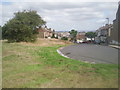
10
The edge of Winns Common
The ridge on which Plumstead Common lies provides fine views northwards across the Thames. This part of Plumstead Common is actually known as Winns Common and all the roads leading down from here to lower Plumstead are very steep. The road ahead is appropriately called Viewland Road and to the right, out of sight, is Heath Villas, giving another clue about the history of the Common.
Image: © Marathon
Taken: 28 Apr 2016
0.03 miles