IMAGES TAKEN NEAR TO
Quilter Street, LONDON, SE18 1JG
Introduction
This page details the photographs taken nearby to Quilter Street, SE18 1JG by members of the Geograph project.
The Geograph project started in 2005 with the aim of publishing, organising and preserving representative images for every square kilometre of Great Britain, Ireland and the Isle of Man.

There are currently over 7.5m images from over14,400 individuals and you can help contribute to the project by visiting https://www.geograph.org.uk
Image Map
Images are licensed for reuse under creativecommons.org/licenses/by-sa/2.0
Notes
- Clicking on the map will re-center to the selected point.
- The higher the marker number, the further away the image location is from the centre of the postcode.
Image Listing (83 Images Found)
Images are licensed for reuse under creativecommons.org/licenses/by-sa/2.0
Image
Details
Distance
1
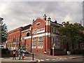
Plumstead Public Library
On the junction of Plumstead High Street (in front) and Quilter Road (on the left).
Image: © David Anstiss
Taken: 21 Aug 2011
0.03 miles
2
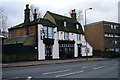
The Electric Orange, Bar, Plumstead
On the junction of Plumstead High Street (on the left) and Rippolson Road (on the right).
Image: © David Anstiss
Taken: 21 Aug 2011
0.04 miles
4
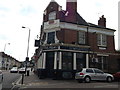
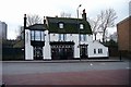
Plume of Feathers Public House
Diagonally across Plumstead High Street from St Nicholas Gardens is the Plume of Feathers public house. Dating back to the time before cars it still has a yard to the right hand side which was used for stables. The left side gardens were originally used by tourists and travellers as a rest stop. Directly opposite the pub is St Nicholas Road which leads to St Nicholas Church.
Image: © Ken Brown
Taken: 3 Feb 2003
0.10 miles
5
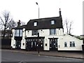
Plume Of Feathers Public House
Opposite St Nicholas Gardens at the top of St Nicholas Road is the Plume of Feathers Public House. To the east of the pub is a large garden that was used by visitors using the terminus that used to be beside the pub in front of the gardens. The west side entrance leads to the old stables as the Inn was a coach stop before trams.
Image: © Ken Brown
Taken: 3 Feb 2003
0.11 miles
6
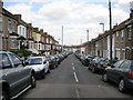
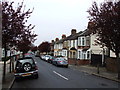
Plumstead: Riverdale Road, SE18
This is Riverdale Road viewed looking down towards the High Street. The pale blue column is a sewer vent pipe, the top of which must be higher than the ridges of the house roofs.
Image: © Nigel Cox
Taken: 15 Apr 2008
0.11 miles
9
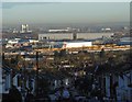
Early morning view down Purrett Road
Purrett Road drops steeply down from Plumstead Common to Lower Plumstead. In this view, taken not long after sunrise, the Barking Creek Barrier is to the left, the two big grey buildings in the distance are known as 'Iron Mountain' - see http://www.geograph.org.uk/photo/2990467 while in front of these the lines of yellow wagons are within a worksite for Crossrail, situated between Woolwich and the southern terminus at Abbey Wood.
Image: © Marathon
Taken: 19 Feb 2016
0.14 miles
10
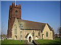
Plumstead: Church of St Nicholas
The foundations of the church date from around 960, while the red brick tower was completed in 1664. On 11 February 1907 an explosion in a magazine in the Chemical Research Department of the Woolwich Arsenal on Plumstead Marshes caused a further explosion of a gasometer causing much damage to surrounding property in Woolwich and Plumstead, including the Church. Fortunately no lives were lost in the explosion. The Church was restored, but also suffered further extensive damage during the Second World War, requiring more restoration work. The result is a hotch-potch of building styles and materials. Nonetheless the building is Grade II* listed. Today the Church claims to be the only place of Christian worship within its parish and serves a population of about 14,000. The Church's website is here http://www.frandrew.dircon.co.uk/
Image: © Nigel Cox
Taken: 26 Mar 2007
0.15 miles