IMAGES TAKEN NEAR TO
East Street, LONDON, SE17 2SB
Introduction
This page details the photographs taken nearby to East Street, SE17 2SB by members of the Geograph project.
The Geograph project started in 2005 with the aim of publishing, organising and preserving representative images for every square kilometre of Great Britain, Ireland and the Isle of Man.

There are currently over 7.5m images from over14,400 individuals and you can help contribute to the project by visiting https://www.geograph.org.uk
Image Map
Images are licensed for reuse under creativecommons.org/licenses/by-sa/2.0
Notes
- Clicking on the map will re-center to the selected point.
- The higher the marker number, the further away the image location is from the centre of the postcode.
Image Listing (207 Images Found)
Images are licensed for reuse under creativecommons.org/licenses/by-sa/2.0
Image
Details
Distance
1
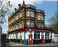
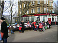
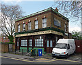
Mason's Arms, East Street
Big brash late Victorian pub which has somehow survived when all its original surrounding housing has long since been cleared away.
Image: © Stephen Richards
Taken: 6 May 2013
0.01 miles
2
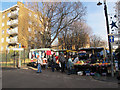
Rummaging for clothes, East Street Market, Walworth
East Street is largely pedestrianised on account of its popular and thriving daily market and local shops. In the background is The Masons Arms, with a To Let sign at first floor level. The trees behind the pub are in Nursery Row Park.
Image: © Robin Stott
Taken: 9 Feb 2014
0.03 miles
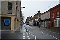
3
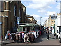
East Street market
Saturday morning and the market is busy. This is at the junction of East Street and Portland Street (the latter being kept clear of stalls as a through route). For other photos of the market see Image and Image
Image: © Stephen Craven
Taken: 10 Dec 2011
0.03 miles
4
East Street Market
East Street, a long-established street market off Walworth Road.
Image: © Malc McDonald
Taken: 12 May 2010
0.05 miles
5
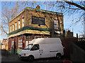
The Crown, Brandon Street
This is the only remaining original building on the east side of Brandon Street. It looked still to be open as of the end of 2011.
Image: © Stephen Craven
Taken: 10 Dec 2011
0.08 miles
6
The former Crown, Brandon Street
Another dead pub, the tiled front and Wenlock Ales signage happily intact, at least for the time being.
At the time of writing (2016) it still appears to be standing, but a few years ago locals were campaigning against developers who wanted to bulldoze it and build seven thousand flats in its place (I may have exaggerated that number).
Image: © Stephen Richards
Taken: 6 May 2013
0.08 miles
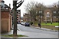
7
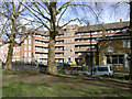
Dawes House across Orb Street, from Nursery Row Park, Walworth
Dawes House is part of the Rodney Estate, presumed to be a housing development by the London County Council in the 1950s. The view is from the older part of Nursery Row Park, with its rows of plane trees. East Street is behind the camera.
Image: © Robin Stott
Taken: 9 Feb 2014
0.08 miles